
| Area | S.F. Trinity |
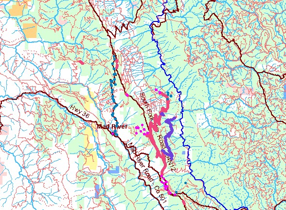
| Topic | Noxious Weeds: South Fork Mtn. Diffuse Knapweed Control 2001, 2003 |
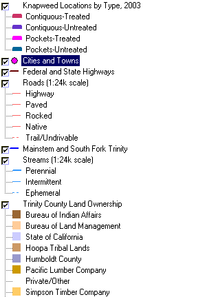
| Click check box next to Knapweed Locations by Type, 2003 or Knapweed Locations by Type, 2001 layer to see location and type of Diffuse Knapweed (Centaurea Diffusa) infestation on South Fork Mountain for each of the two project years. The population of diffuse knapweed, an A-rated noxious weed by the California Department of Food and Agriculture, on South Fork Mountain is one of the largest in the state of California. Data collected by the Trinity County Weed Management Cooperative. Scale = 1:200,153 . | |||
 |
 |
||
To view metadata about a map layer, click on a link in the table below.
| Name of Layer in Map Legend | Metadata File Name |
|---|---|
| Knapweed Locations by Type, 2003 | sf_knapweed_2003.shp.txt |
| Cities and Towns | tc_towns.shp.txt |
| Federal and State Highways | tc_mjrds.shp.txt |
| Roads (1:24k scale) | tc_trans.shp.txt |
| Mainstem and South Fork Trinity | trin_riv.shp.txt |
| Streams (1:24k scale) | tcsf_str.shp.txt |
| Trinity County Land Ownership | tc_gown.shp.txt |
| Humboldt County Land Ownership | hc_gov-own2.shp.txt |
| Topographic Map (1:24k scale) | trinity.sid.txt |
| www.krisweb.com |