
| Area | Upper Klamath |
| Topic | PH: Maximum of All Samples Lost River at 17 Sites (BOR) 1993-1996 |
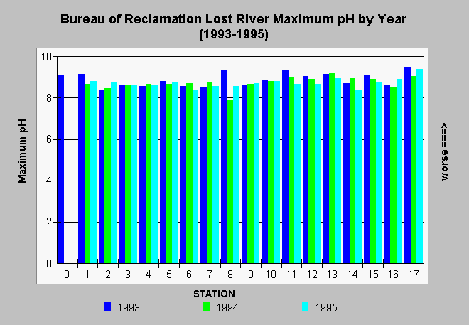
| Caption: Seventeen stations along the Lost River in California and Oregon have been monitored by the staff of the Bureau of Reclamation Klamath Falls Oregon Field Office. Profiles suggest that pH was highest in 1993 which was not the driest of the sequence of years measured. The rise in pH is often linked with algal blooms, which occur later in the season. Although pH is somewhat elevated, the Lost River is not exhibiting acute pH levels similar to Upper Klamath Lake. Water quality samples at each site include measurements at the surface, at one meter in depth, and just up off the bottom. Click on Info Links for more information. | |
 |
To learn more about this topic click Info Links .
To view additional information (data source, aquisition date etc.) about this page, click Metadata .
To view the table with the chart's data, click Chart Table web page.
To download the table with the chart's data, click lrgphmax.dbf (size 2,012 bytes) .
To view the table with the chart's source data, click Source Table web page.
To download the table with the chart's source data, click lostrwq.dbf (size 268,498 bytes)
| www.krisweb.com |