
| Area | Upper Klamath |
| Topic | PH: Monthly Samples Lost River Basin at 8 Sites (NCRWQCB) 1992 |
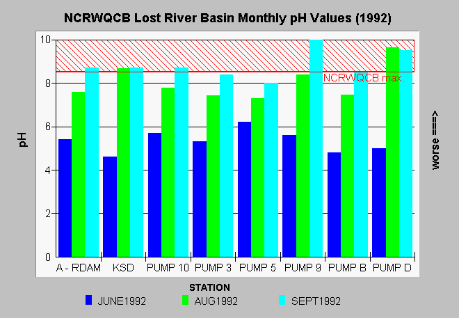
| Caption: This chart summarizes data collected by the California North Coast Regional Water Quality Control Board (NCRWQCB) staff at eight Lost River Basin locations. The NCRWQCB has set a standard of 9 for pH in order to protect fisheries and other beneficial uses of water. Only the sampling stations at Pump 9 and Pump D exceeded this standard during the time when samples were being collected. The chart above shows an increasing pH trend from June to September 1992 except at Pump D. This rise in pH may be related to algae blooms as the process of photosynthesis causes pH to rise (Winchester, 1995). Another cause of high pH in the Upper Klamath Basin is alkaline springs or soils. Runoff from alkaline soils can occur during rain storms or as a result of irrigation. Click on the Info links tab above for more information. | |
 |
To learn more about this topic click Info Links .
To view additional information (data source, aquisition date etc.) about this page, click Metadata .
To view the table with the chart's data, click Chart Table web page.
To download the table with the chart's data, click lrph.dbf (size 722 bytes) .
To view the table with the chart's source data, click Source Table web page.
To download the table with the chart's source data, click lostdat1.dbf (size 21,210 bytes)
| www.krisweb.com |