
| Area | Upper Klamath |
| Topic | Conductivity: Monthly Max Lost River Basin at 8 Sites (NCRWQCB) 1992 |
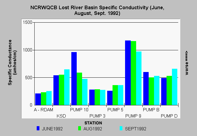
| Caption: Of all eight Lost River Basin stations measured by North Coast Regional Water Quality Control Board (NCRWQCB) staff, Pump 9 in the Klamath Project had the highest conductivity of any location regardless of season. The June 1992 sample at Pump 10 was also high. NCRWQCB standards for specific conductance vary with location: maximum for Clear Lake is 300 umhos, lower Lost River is 1000 umhos and Tule Lake allowed maximum is 1300 umhos. The location of the samples with PUMP designations are within the Klamath Project, KSD = Klamath Straights Drain and A-RDAM = Anderson Rose Dam. | |
 |
To learn more about this topic click Info Links .
To view additional information (data source, aquisition date etc.) about this page, click Metadata .
To view the table with the chart's data, click Chart Table web page.
To download the table with the chart's data, click lrcond.dbf (size 722 bytes) .
To view the table with the chart's source data, click Source Table web page.
To download the table with the chart's source data, click lostdat1.dbf (size 21,210 bytes)
| www.krisweb.com |