
| Area | Upper Trinity |
| Topic | Sediment: Upper Trinity - Sediment Inputs Percent 1981-2000 |
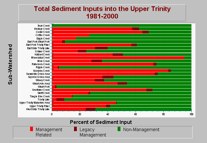
| Caption: This chart displays the relative proportions of total sediment inputs summarized by management and non-management sources for sub-watersheds within the Upper Trinity Planning Watershed between 1981-2000. Management related erosion sources consist of mass wasting, fluvial, and surface erosion processes that are related to timber harvest, roads, and mining activities. Non-Management related erosion sources include landslides from forested areas, bank erosion, and soil creep. Management and legacy management sources contribute significant volumes of sediment into the stream systems. The non-management erosion yield does not necessarily represent long-term background rates due to yearly variations in the degree of wetness. A detailed breakdown of sediment source components is available in the Chart and Source tables. Data are from Graham Matthews and Associates Trinity River Sediment Source Analysis (2001). See Info Links for methods and other background information. | |
 |
To learn more about this topic click Info Links .
To view additional information (data source, aquisition date etc.) about this page, click Metadata .
To view the table with the chart's data, click Chart Table web page.
To download the table with the chart's data, click sed_budget_inputs_upper_trinity_gma_1981_2000.dbf (size 6,187 bytes) .
To view the table with the chart's source data, click Source Table web page.
To download the table with the chart's source data, click sed_budget_inputs_trinity_gma_1981_2000.dbf (size 14,916 bytes)
| www.krisweb.com |