
| Area | Upper Trinity |
| Topic | Sediment: Upper Trinity - Slide Volumes by Land Use 1979-2000 |
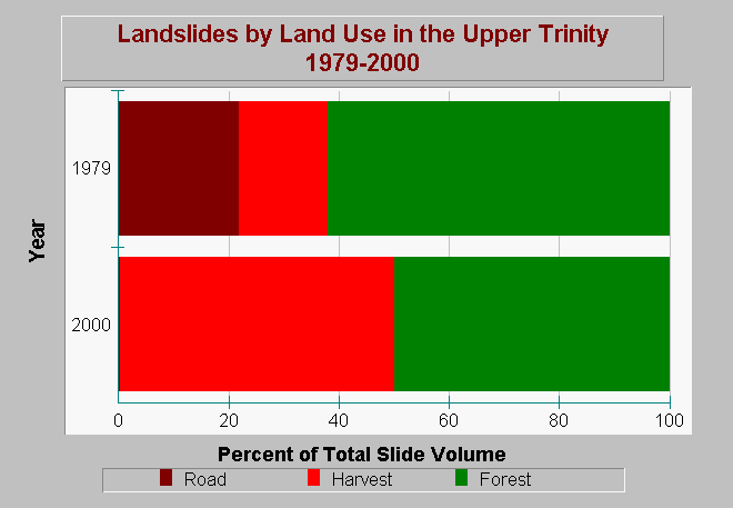
| Caption: This chart shows the percent of total sediment volume resulting from landslides in the Upper Trinity River Planning Watershed. Landslide data are limited to only part of entire watershed. Landslides are categorized by land use associations that include categories of road, harvest, or forest. Road and harvest landslides are considered management related. Forest slides were identified in non-managed areas. The total sediment production has increased from 1979 to 2000. Road related slide volumes have decreased; however, harvest and forest sediment production have increased. Harvest related slide volumes yielded 50% of the total in 2000. Data are from Graham Matthews and Associated Trinity River Sediment Source Analysis (2001). See Info Links for more information. | |
 |
To learn more about this topic click Info Links .
To view additional information (data source, aquisition date etc.) about this page, click Metadata .
To view the table with the chart's data, click Chart Table web page.
To download the table with the chart's data, click sed_slides_type_upper_trinity_gma_1944_2000.dbf (size 608 bytes) .
To view the table with the chart's source data, click Source Table web page.
To download the table with the chart's source data, click sed_slides_type_pw_trinity_gma_1944_2000.dbf (size 1,385 bytes)
| www.krisweb.com |