
| Area | Upper Trinity |
| Topic | Map: 1I. Vegetation Change 1994-1998, Upper Trinity Sub-Basin |
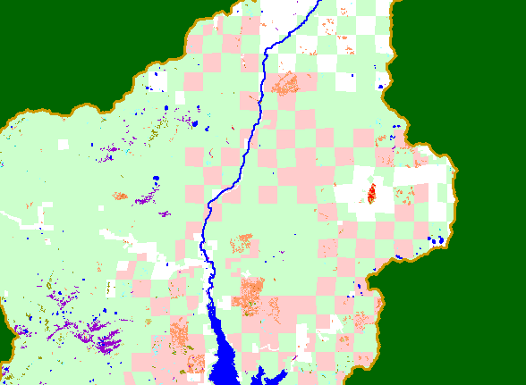
| This is a map of vegetation change for the years 1994-1998 in the Upper Trinity sub-basin above Trinity Lake, displayed with land ownership, the Trinity River, Trinity Lake, and sub-basins. Each block in the checkerboard pattern of land ownership is approximately one square mile. The orange/red colors in the vegetation layer show canopy losses of 16-100% over a 4 year period and indicate substantial timber harvesting (and possibly some wildfires) in the area. Data were provided by the U.S. Forest Service Spatial Analysis Lab in Sacramento, CA. | |||
 |
 |
||
To view metadata about a map layer, click on a link in the table below.
| Name of Layer in Map Legend | Metadata File Name |
|---|---|
| Subbasins (no labels) | subbasins_trin.shp.txt |
| Frame Project Outline | Unavailable |
| Lakes | tc_lakes.shp.txt |
| Mainstem and SF Trinity River | trin_riv.shp.txt |
| Change in Veget. (1994-98)(TIFF) | vegchg.tif.txt |
| Trinity County Land Ownership | tc_gown.shp.txt |
| USFS Vegetation Size (1999)(TIFF) | vegsize99.tif.txt |
| USFS Vegetation Size (1994)(TIFF) | vegsize.tif.txt |
| EPA Landcover (1992 Aggregated)(TIFF) | lndcov2.tif.txt |
| Topographic Map (1:24k scale) | trinity.sid.txt |
| Project Background | trin_outl.shp.txt |
| www.krisweb.com |