![]()
State-of-the-art approaches to ecosystem management recognize that different impact mechanisms produce different impacts in different watersheds, so the approaches are designed to provide different management prescriptions in different areas. Despite this level of understanding, there remains a widespread desire to identify a suite of indicators of lotic ecosystem "health" that are applicable regionally or nationally, and geomorphological attributes of channel form and character have frequently been selected to fill this need. Such attributes, however, often do not satisfy the minimum requirements for a useful environmental indicator. Channel form usually responds slowly to changes in driving variables, the nature of the response differs greatly over small distances, a change in channel form cannot be readily interpreted to infer cause, and trends in channel condition are not necessarily associated with trends in lotic ecosystem condition. In some areas, maintenance of desired ecosystems requires that a range of channel conditionsboth "good" and "bad"be present at any time to ensure that phenotypic and genotypic variability are preserved, that cycles of change which produce future prime habitats are unbroken, and that indirect habitat dependencies are adequately sustained. In such cases, if a monitoring program revealed uniformly "good" conditions, severe ecological disruption could follow. Geomorphological channel characteristics may well be the most useful and tractable indicators for some applications, but which characteristics are relevant and interpretable can be determined only on a case-by-case basis.
Key phrases: selecting monitoring variables for assessing lotic ecosystem condition
Key words: monitoring, lotic ecosystems, natural variability, geomorphology, cumulative impacts, Pacific salmon, indicator variables
![]()
Ecosystem condition in streams and rivers is a topic of great concern through much of the United States, and environmental management plans and regulatory requirements are being designed and implemented with an eye toward maintaining the health of these ecosystems. In this context, an ecosystem has been defined as "healthy" if it "...maintains its complexity and capacity for self-organization" (Norton 1992). Monitoring is a key component of most state-of-the-art approaches to ecosystem management and regulatory environmental oversight. Many programs attempt to use a regionally prescribed suite of physical in-channel variables as surrogate indicators for aquatic ecosystem condition. This paper examines some of the roles intended for in-channel monitoring and discusses the applicability of regional in-channel indicators. The paper then draws on concepts of ecosystem management to outline an alternative approach to indicator selection that may be useful in settings for which regionally uniform indicator suites are not appropriate.
Several efforts to design large-scale environmental monitoring programs have recently been instituted, and these plans often include components designed to assess lotic ecosystems. The following examples illustrate the variety of monitoring needs and goals that are involved.
Environmental management and effectiveness monitoring
State-of-the-art environmental management plans acknowledge that the current state of ecosystem knowledge is imperfect, so they generally incorporate an element of "adaptive management": outcomes of actions are to be monitored so that future decisions can benefit from experience. In the Pacific Northwest, for example, effectiveness monitoring is an essential component of the Northwest Forest Plan (USDA and USDI 1994a). Effectiveness monitoring is intended to be the feedback mechanism whereby the Northwest Forest Plan can be continually improved to better meet its objectives.
MacDonald et al. (1991) describe the role of effectiveness monitoring as "to evaluate whether the specified activities had the desired effect", and further indicate that such monitoring could apply to individual components of a project or to the overall plan. In the latter case, the status of the beneficiaries of the plan is generally monitored, but MacDonald et al. (1991) note that such measurements are often difficult to relate to individual components of the plan. In other words, such an approach may reveal that a plan is failing, but it is not likely to reveal the reason for failure. A consistent approach to measuring "success" of the overall plan needs to be adopted over the area affected by the plan so that an assessment of overall effectiveness is meaningful. Monitoring of the overall effectiveness of a large-scale plan is useful primarily for informing conservation strategies of future generations rather than for supporting short-term adaptive management. Large-scale ecosystem management efforts such as the Northwest Forest Plan are not expected to influence overall conditions significantly for several decades, so results of monitoring are unlikely to be useful for improvement of land management over time scales of less than 20 to 40 years.
On a shorter temporal and smaller spatial scale, the effectiveness of individual components of an adaptive management plan needs to be evaluated; adaptive management cannot be carried out in the absence of an effectiveness monitoring program. To be most useful, this kind of monitoring program must provide direct feedback on the effectiveness of specific components of the management plan, it must provide the information in such a way that the necessary adaptations for management can be identified, and it must do so as quickly as possible so that changes can be made before ineffective components allow degradation to proceed too far. For these purposes, use of a consistent set of measurement attributes is unnecessary and may be inappropriate. Far more important is selection of attributes that are relevant and interpretable in the spatial and temporal context of the land management experiment.
Regulatory oversight and compliance monitoring
Regulatory agencies rely on monitoring as the means by which compliance to regulations can be evaluated and enforced. The Environmental Protection Agency (EPA), for example, calls for monitoring of pollutant loads in some streams to ensure that a prescribed "Total Maximum Daily Load" (TMDL) for a pollutant is not exceeded, and individual states have set standards for some water quality components. Similarly, the National Marine Fisheries Service (NMFS) has selected a suite of indicators for use in determining whether lotic ecosystem conditions meet Northwest Forest Plan objectives: "Properly functioning values for these aquatic, riparian, and watershed matrix elements correspond directly with, and are the best means to evaluate compliance with, the Northwest Forest Plan Aquatic Conservation Strategy objectives that are important to Pacific salmonids" (NMFS 1997).
Compliance monitoring differs from effectiveness monitoring in the nature of the intended standard of comparison: compliance monitoring obtains results for comparison against a formally specified standard or threshold (i.e., "the peak arsenic concentration on 30 July was 30% higher than allowed at the mouth of the pipe"), while effectiveness monitoring ordinarily reports a level of effectiveness on a continuous, often ad hoc, measurement scale (i.e., "the modified procedure reduced average arsenic concentrations by 14%, as measured at the Cedar Street bridge"). Compliance monitoring thus cannot be carried out unless a standard for compliance has been set, and in most cases the nature of the standard determines the nature of the monitoring program. As was the case with effectiveness monitoring, compliance monitoring can be carried out at two distinct scales. In the first case, overall compliance can be tested for a large system (e.g. "does the Sacramento River at Sacramento meet state water quality standards?"). Information at this scale can be used to identify a problem, but it is of little use in diagnosing the cause for or solving the problem if activities carried out away from the monitoring site influence conditions at the site, as is the case with most in-channel attributes.
At a smaller scale, compliance monitoring can be linked to individual activities if standards have been set for those activities. Thus, effluent from a sewage treatment plant may be monitored to ensure that the concentration of heavy metals remains below the maximum permitted. To be most useful, attributes monitored at this scale must strongly reflect management practices and must show little lag-time between activity and response. Non-management-related influences on the attribute must be well understood and separable from management-related influences. Such programs also require consistency: those who are being held to compliance need to know they are being judged equitably.
National accounting and trend monitoring
Some desire a uniform measure for assessing environmental conditions across the nation. If consistent measures of ecosystem impairment were adopted, environmental conditions of one area could be compared to those of another, and nation-wide environmental trends could be tracked readily through time. Two of the four objectives of the Ecological Monitoring and Assessment Program (EMAP) of the EPA, for example, are to "estimate the current status, trends, and changes in selected indicators of the condition of the Nations ecological resources on a regional basis" and to "provide annual statistical summaries and periodic assessments of the Nations ecological resources" (Thornton et al. 1994). Such information is desired for promoting environmental accountability, for supporting consistency in administration and enforcement of regulations, and for assessing the effectiveness of large-scale approaches to environmental management.
Attributes that could be usefully monitored for such a broad-scale program would need to adequately represent the condition to be reported. There is no attribute-based definition of ecosystem health just as there is no attribute-based definition of human health; in the words of D. Ehrenfeld, "Health is an idea that transcends scientific definition" (Ehrenfeld 1992). In both cases, however, indices of health could be constructed to highlight particular patterns of interest (e.g. average number of sick-days used per year per full-time employee) while ignoring other aspects of the problem (e.g. the health of people without full-time employment). In contrast, measurements of components influencing overall "health" over wide areas are often unambiguous: arsenic concentrations or cases of bubonic plague can be measured and reported with great consistency.
Other roles for monitoring
Monitoring is also carried out for a variety of other reasons at a variety of other scales, and these are well described by MacDonald et al. (1991). In particular, monitoring is a vital component of environmental research. Such applications generally involve monitoring programs that are carefully designed to answer well-defined questions in as efficient a way as possible, and monitoring protocols are guided by the specific needs and opportunities posed by the problem and study site under consideration. Monitoring variables are carefully selected to avoid ambiguous results, and the nature of cause-effect relationships either is well-understood or the project is constructed to shed light on hypothesized relationships. In-channel physical parameters often are the most useful monitoring variables for such applications, but in each case the variables used are selected to be relevant to the specific application. Research programs might be designed to test the applicability of regional channel-based indicators, but otherwise such parameters would rarely be considered at a regional scale.
Monitoring is also an important tool for determining whether particular practices have been implemented. For this application, the land-use practices to be assessed themselves constitute the monitoring variables, and only where practices are prescribed on a regional scale are monitoring variables defined on a regional scale. Implementation monitoring rarely uses in-channel variables.
Because research and implementation monitoring programs rarely involve use of standardized in-channel variables on a regional scale, these kinds of monitoring are not further discussed in this paper.
For each of the above examples of effectiveness, compliance, and trend monitoring, there has been considerable interest in adopting a single suite of indicator variables that can be measured in the same way throughout the area of interest. Such an approach would produce consistent data that can be compared with statistical validity across large areas. Many of the biologists designing the aquatic components of the programs have proposed use of geomorphological channel characteristics, such as width-depth ratios, pool spacing, bank stability, and woody debris loading, as indicators for lotic ecosystem condition.
Table 1. Interim riparian management objectives (from USDA and USDI 1994b)
The federal interagency PACFISH program (USDA and USDI 1994b), for example, designed an approach to ecosystem management for use on federal lands throughout much of the range of Pacific salmon in the western United States. The plan lists threshold values of six channel characteristics for use as "interim riparian management objectives" (Table 1), thus defining regionally applicable standards of compliance for anadromous fish habitat and establishing the measure for effectiveness monitoring: "The interim RMOs...provide the criteria against which attainment, or progress toward attainment, of the riparian goals are [sic] measured" (USDA and USDI 1994b). Threshold values can be altered if sufficient local information exists to support such changes; otherwise, interim objectives are adopted. Selection of the defined objectives was based on the assumption that they "...are good measures of ecosystem health and are easily quantified and subject to accurate, repeatable measurements" (USDA and USDI 1994b). All of the identified indicators of lotic ecosystem health are physical channel characteristics.
The National Marine Fisheries Service has taken a similar approach (NMFS 1996) to the selection of compliance criteria for the Northwest Forest Plan and Endangered Species Act determinations, but has expanded the list to include 18 indicators. In addition, threshold values for "properly functioning", "at-risk", and "not properly functioning" aquatic ecosystems are specified. In this case, too, threshold values may be modified to suit local conditions if sufficient data exist. Fifteen of the indicators are in-channel physical characteristics (e.g. temperature, substrate grain size, physical barriers, change in drainage density), and the remaining three are management characteristics (road density, presence of riparian reserves, and disturbance history).
Table 2. Essential and desirable properties of indicators for monitoring
1. Channels integrate everything upstream
2. Channels are less complicated than the biota within them, so changes are more likely to be interpretable
3. Channel characteristics define the physical habitat for lotic biota
4. Physical channel characteristics are easier to measure than biological variables
5. Many channel characteristics show little seasonal variation
Properties such as these might indeed increase the convenience of an otherwise valid indicator. However, these properties are not the primary criteria needed to ensure that an indicator is valid or useful.
The properties required of a useful indicator have been discussed at length in numerous publications (Table 2; and see NRC 1995, MacDonald et al. 1991). Although different authors highlight different properties, most agree on several points:
1. An indicator must respond quickly enough to provide results in the time-frame desired
2. The cause-effect relationships that control the indicator response must be well understood
3. Changes must be interpretable in terms of the objectives of the program
4. The signal must be statistically separable from the noise
5. Measurements must be cost-effective at the required level of precision and accuracy
Because of the frequency with which geomorphological characteristics tend to be selected as indicators of biological conditions, it is useful to evaluate the suitability of commonly selected physical channel characteristics with respect to this short-list of necessary properties.
Table 3. Typical response times, recovery times, and influences on the physical indicator variables for channel condition used by PACFISH (USDA and USDI 1994b) or NMFS (1996).
2 Lengthy recovery times are particularly common when the variable is affected by a cascade of interacting mechanisms. For example, if landslides are triggered by drainage failures on roads abandoned for 30 years, gravel embeddedness and inter-gravel fines will not recover from the impacts of road construction for nearly half a century after roads were built.
Response time
An important objective of both effectiveness and compliance monitoring is to provide information that can be used to modify management practices, and this requires that information be available before those practices cause irreparable damage. Measurements of channel form (e.g. pool frequency and width-depth ratio) are not capable of providing information at the required time-scale because channel form responds slowly to management-related changes in driving variables (Table 3).
Geomorphological studies have repeatedly documented lengthy lag times for channel responses to sediment inputs. Gilbert (1917), for example, demonstrated that the aggradational front for sediment from long-discontinued hydraulic mining in the Sierra Nevada foothills was still progressing through the Central Valley. Similarly, Trimble (1983) found that the form of low-order channels in the Coon Creek watershed of Wisconsin responded quickly to agricultural impacts of the last century, while downstream channels are still adjusting today. In Redwood Creek, California, logging-related impacts on channel morphology only became evident when major storms occurred, and parts of the channel are only now responding to sediment introduced by the 1964 flood (Madej and Ozaki 1996). Similarly, Frissell et al. (1997) note that it may take another major flood to allow channel morphology to recover, even if upslope practices have indeed improved to the point that recovery is possible. Such situations would make some channel-form parameters unusable as indicators, as the existence of a signal would depend more on the past history of impacts than on the strength of modern driving variables. In Redwood Creek, for example, long-term monitoring data demonstrate a statistically significant trend of channel incision along the middle reaches. However, these data neither indicate that todays land-use practices are triggering arroyo formation nor demonstrate that sediment input problems have been solved. Instead, the data simply document the length of time required for the channel to recover from morphological changes wrought by the very large storm of 1964.
Lag times in channel response are due both to the relative slow transport time for bed material and to the dependence on major storms for accomplishing the changes (Madej and Ozaki 1996). An indicator that shows no response until a major storm occurs is not particularly useful if the intent of monitoring is, in part, to avoid major impacts.
Timeliness is especially important for compliance monitoring. A compliance monitoring program cannot achieve its objectives if the signals revealed by the program are generated by historical activities rather than by the activities for which compliance is to be tested.
Interpretation of cause
Effectiveness monitoring is a critical component of adaptive management programs, and compliance monitoring is often used to regulate individual sources of pollutants. The most useful measurements for both of these applications would thus allow interpretation of what practices are ineffective in meeting plan objectives or compliance standards and would allow diagnosis of why they are ineffective. An indicators signal cannot be interpreted for these purposes if the causal linkage between the management practices and the indicator variable is not known, or if the cause cannot be inferred from the response.
Inference of cause is not possible if an indicator responds in the same way to multiple stressors. Just as the reason for declining salmon populations cannot be inferred from population monitoring data alone, the reason for altered channel form cannot be inferred from channel measurements alone. Thus, channels may widen due to an increase in sediment load (Madej 1982), alteration of riparian vegetation (Kondolf and Curry 1986), an increase in runoff (Abbott 1976), or for other reasons (Figure 1). Each of these changes, in turn, may be caused by any of a variety of land-use activities. In addition, channels tend to widen during major floods and gradually reassume their earlier forms in following years (Wolman and Gerson 1978, Lisle 1981), so any condition of channel form must be evaluated with respect to the timing of past channel-altering floods. A change in channel form at a site rarely reflects land-use activities only at that site.
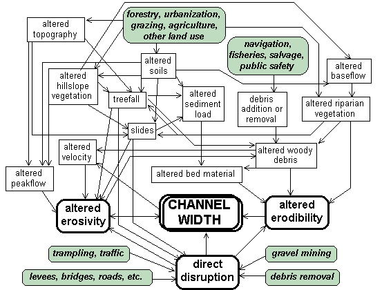
Fig. 1. Potential influences on channel width. Land-use activities triggering change are shown in shaded boxes.
Worse, different parts of the channel system may respond to the same change in driving variables in different ways. Construction of a dam, for example, may induce channel scour immediately downstream (Pemberton 1975) and aggradation further downstream (Petts 1984). In other cases, a single environmental change may result in alternating periods of aggradation and degradation along a single reach (Womack and Schumm 1977, Petts 1979, Blong 1966). Similarly, occurrence of a major storm may excavate small channels and aggrade large channels in some areas and have the opposite effect in others. A geomorphologist can anticipate such behaviors on the basis of localized, system-specific knowledge, but it should be evident that a parameter would make an unwieldy indicator for general use if every response (or absence of response) requires intensive, system-specific, retroactive interpretation.
Correspondence to program objectives
In cases where attributes representing ecosystem health are to be monitored, the programs objectives presumably includeat least implicitlythe maintenance of ecosystem health. If attainment of desired values for the selected indicators does not produce a corresponding improvement in ecosystem health, then program objectives cannot be met. As currently applied, use of indicators based on physical channel parameters can sometimes hinder attainment of program objectives.
Particularly in the case of national or regional trend monitoring, selection of a single suite of indicators for use over broad areas is likely to be ineffective in promoting ecosystem health because ecosystem health is being impaired by vastly different suites of influences in different parts of the reporting area. For example, an improvement in each of the characteristics listed in Table 1 does not mean that salmon populations are not being progressively decimated by interactions with exotic species, increased predation due to altered riparian ecosystems, lethal estuarine conditions, increased turbidity, and high recreational fishing pressure in one area; and by road-related blockage of intermittent tributaries used as winter refuge habitat, chemical contamination, commercial fishing pressure, and disease in another area. A regional "report card" that shows that interim riparian management objectives are being met is not particularly relevant with respect to the actual condition or trend of salmon stocks. Without a prior understanding of the relative importance of the stressors that influence the species of interest in the watershed of interest, the indicators interpretable with respect to those species in that watershed cannot be identified.
Even where channel form is a dominant influence on lotic ecosystem health, uncritical acceptance of form-related monitoring parameters can defeat program goals. Studies in Oregon suggest that periodic "destruction" of aquatic habitat may be necessary in that area to reestablish the highest quality habitat for anadromous salmonids (Reeves et al. 1995, Bisson et al. 1997), just as riparian ecosystems can be sustained only through periodic disturbance. Thus, the full distribution of channel conditions must be allowedand even valuedto ensure that prime habitat will always be available somewhere in the system. In this context, the condition of any one channel reach is essentially irrelevant; system condition can only be evaluated by considering the distribution and range of the condition of channels throughout the system.
In Oregons Elk River system, for example, small areas of landslide-affected channel having "undesirably" high width-depth ratios and water temperatures are literal hot-beds of primary productivity. Important aquatic ecosystems along reaches with low primary productivity further downstream are sustained by the inflow of nutrients from these sites (G. Chen, personal communication). If all channels in this system were modified to be "ideal" (having the desired width-depth ratio, water temperature, bank stability, woody debris load, and so on), the aquatic ecosystems in the watershed would be damaged; attainment of desired PACFISH (USDA and USDI 1994b) indicator values would itself defeat the programs objectives. In the context of the selection of target values for indicators of lotic ecosystem health, traditional approaches to monitoring thus are constructing a Procrustean stream bed: the integrity of natural systems would be destroyed if channels were forced through habitat-modification projects to measure up (or down) to the assumed ideal.
In addition, where specified, the desired values for in-channel indicators (e.g. USDA and USDI 1994b, NMFS 1996) are based primarily on summer-time observations of fish distribution and survival. Grossman et al. (1995), however, demonstrate that such observations may be deceptive, arguing that small patches of other habitat conditions may be critical for sustaining abundance at sites with high population densities. Such is the case in coastal streams of Washington, where channels that do not even carry flow during traditional observation periods provide winter refuge for a high proportion of the Clearwater Rivers juvenile coho salmon (Peterson and Reid 1984). Nickelson et al. (1992) also argue that habitat conditions which promote winter survival are more important than summer habitat, but note that not enough is known about what makes good winter habitat to identify desirable channel characteristics. In some cases, managing for summer habitat may decrease winter survival (Cunjak 1996).
There is also some question about whether even summer-time habitat needs are adequately understood. Even the traditional assumption that populations of anadromous fish depend on high-quality pool habitat may not be well-founded. Observations in Elder Creek, a near-pristine tributary of the Eel River in northwest California, show a relatively high population of steelhead in a channel that naturally has a relatively low population of pools (W. Trush, personal communication), and Bisson et al. (1982) found that age 0+ steelhead avoid pools. Furthermore, some widely adopted habitat goals do not reflect the actual range of channel conditions in a natural setting. A width-depth ratio of less than 10, as specified by both PACFISH (USDA and USDI 1994b) and NMFS (1996), is not commonly encountered in many natural channels (Rosgen 1994), and NMFS (1996) classifies bedrock and sand-bedded channels as "not properly functioning".
In addition, there has been a strong tendency to select target indicator values to reflect presumed habitat needs of a few important species, yet ecosystem health requires that the distribution of habitat conditions suit the needs of all components of the ecosystem. A channel system deemed by NMFS to have "properly functioning" substrate (i.e. gravel) is distinctly dysfunctional from the point of view of Pacific lamprey (Lampetra tridentata), yet Pacific lamprey are as valid a component of Pacific Northwest lotic ecosystems as Pacific salmon. Similarly, modification of in-channel conditions to better meet target values for channel habitat indicators has reduced habitat quality for the foothill yellow-legged frog (Rana boylii; Fuller and Lind 1992), a species listed by the State of California and by USDA Forest Service Region 5 as being in need of special protection. Furthermore, we cannot know, a priori, that the portions of the natural ecosystem needed to sustain lamprey and yellow-legged frog populations are not indirectly critical to the survival of Pacific salmonids. It may not be possible for wild salmon to survive in isolation from their native ecosystems, and lampreyand the environments which juvenile lamprey preferare an integral part of those ecosystems.
Finally, individual compliance or effectiveness cannot be assessed using indicators influenced by a variety of conditions and activities over a wide area. In-channel physical characteristics at a particular location reflect the full distribution of conditions throughout the upstream watershed.
Background variability
Added to the problem of poorly understood in-stream habitat needs is the complication that habitat quality, by its very nature, cannot be assessed at a site. Resilience of a species depends in part on the existence of a wide range of phenotypes and genotypes that, through a diversity of behaviors and adaptations, can ensure that enough individuals survive a catastrophe that the population can be rebuilt. Both phenotypic and genotypic diversity are made possible, in part, through geomorphic diversity (Frissell et al. 1997); preservation of biodiversity therefore requires preservation of geodiversity (Healey and Price 1995). Once again, a healthy lotic ecosystem requires that different parts of a channel system exhibit very different in-channel conditions and that those conditions change through time; this variation is an essential characteristic of naturally functioning channel systems and of the ecosystems they support.
Given that many biologists consider stocks of salmon to be different enough from one another to require preservation in their own right, it should come as no surprise that the differences in geomorphic characteristics that gave rise to the distinctive stocks are every bit as profound as the differences between stocks. The nature of pristine Elder Creek in the northern California Coast Range, for example, demonstrates that low pool frequencies are within the range of conditions to which particular stocks of anadromous salmonids have adapted. The ideal indicator shows a low level of natural variability so that relevant changes can be statistically differentiated from background "noise". Channel morphology, in contrast, shows a high level of natural variability both in time and in space (Benda 1990), and that variability is itself essential for the preservation of the species and ecosystems of interest.
Water temperature standards are an example of the way in which lack of information about fish behavior and over-simplification can lead to the adoption of indicators for which meaningful measurements cannot be readily made. NMFS describes properly functioning habitat as having stream water temperatures of 10° to 14°C (NMFS 1996), while PACFISH calls for maximum stream temperatures of less than 20°C (USDA and USDI 1994b). Such standards are based to a large extent on laboratory observations of anadromous salmonid survival in tanks. Because fish cannot escape from the temperatures applied during such experiments, results isolate the physiological response to elevated temperatures and do not adequately account for other kinds of coping strategies.
In reality, however, natural stream temperatures vary widely through the range of the Pacific salmon, within individual watersheds, and within individual pools, and this variation allows behavioral strategies for coping with the physiological problem. Mean August air temperatures, for example, vary between 14° and 27°C over a 125-km transect of coho salmon habitat from Eureka, California, to Whiskeytown, California. Because water temperature is strongly influenced by air temperature, natural water temperatures would also have varied considerably over this distance. Within a watershed, water in the smallest tributaries reflects groundwater temperatures, but this water quickly warms if ambient air temperatures are higher than those of the groundwater. In larger channels, where water has begun to equilibrate with air temperatures and riparian shading is less effective, water temperature may be substantially higher. Thus there are often patches of cold water where small tributaries or groundwater enter larger streams. In deep river pools, surface water temperatures have been found to be as much as 7.8°C higher than those of the water at depth, for example (Nielsen et al. 1994). Under natural conditions, fish preferring particular water temperatures simply frequented the parts of the system in which those temperatures were present, and Berman and Quinn (1991) found that spring chinook in the Yakima River were able to maintain a body temperature about 2.5°C cooler than the average water temperature by spending a disproportionate amount of time in sites with lower-than-average temperatures. If fish are using deep pools as thermal refuges, then shallowing of those pools may increase thermally-generated stress by increasing the mixing of warm and cool water: homogenization would greatly raise the refuge temperatures while slightly decreasing monitored stream temperatures elsewhere.
That temperatures were not uniform throughout natural systems permitted a wider diversity of ecosystem components than a uniform temperature would have allowed. From a monitoring point of view, this inherentand ecologically necessaryvariability produces a considerable logistical challenge. Where, exactly, should temperature be measured to determine whether the system is properly functioning? And if temperatures vary widely through space and time, how is a significant change recognized? And if we cannot know the original spatial and temporal distribution of temperatures, what measurements would indicate that the system is impaired? A similar suite of questions is relevant for each of the physical channel variables listed in Table 1.
Cost effectiveness
The final general requirement for effective indicators is that they can be monitored cost-effectively at the required levels of precision and accuracy. The above discussion indicates that to be useful, measurements of channel form or water temperature would need to be carried out on a sampling basis throughout a watershed for results to be interpretable in terms of ecosystem health. Because form responds slowly to management-induced changes and because major changes in form generally require the occurrence of a major storm, the required period for monitoring would need to be on the order of multiple decades to disclose trends of channel change and to discern management-related trends from trends of recovery from individual storms. Within each watershed, replicate measurement reaches would be required for different vegetation types, different channel orders, different channel gradients, different geologic substrates, and different ages of management, as all of these conditions are likely to affect channel morphology. And although water temperature responds quickly to changes in shading, it is also affected by changes in form; a monitoring program intended to assess trends in stream temperature would thus require the same time-scale as that needed for assessing changes in channel form. To be useful, then, such a program would require a long-term commitment to repeated surveys of numerous sites in each watershed selected for monitoring.
Ramifications of inadequate indicators
Noss (1990) points out that indicators often are selected for reasons other than their ecological suitability. Thus, photogenic "celebrity" species are traditionally monitored in part to satisfy public expectations, and many indicators have been selected simply because some data already exist. In the present case, monitoring of channel form may be undertaken because it is a simple extension of traditional habitat inventories, and protocols already exist. In addition, scientists and resource professionals are well-positioned to understand the overwhelming complexity of their own field, but there is a strong tendency to assume that less familiar fields of study are less complicated: biologists tend to perceive community composition as intractably complicated while channel form is intuitively obvious; geomorphologists see community composition as intuitively obvious and channel form, intractably complex.
Noss (1990) further points out that selection of indicators on the basis of non-ecologically based criteria will result in indicators that cannot be interpreted with respect to ecologically-based problems. In some cases, the program objectives may be broad enough that selection of ecologically unsuitable indicators may be justified because of their ability to meet the needs of non-ecological objectives, such as public education. For the applications under discussion here, however, such a decision would not merely be benign.
Embarking on a lengthy monitoring program using indicators which are known or suspected to be inadequate would be harmful for at least six reasons. First, even if a parameter (say, percent pool area) is adopted simply as an indicator for other, harder-to-measure quantities, it is the nature of institutions to displace goals from attainment of the non-accountable objectives (ecosystem health, for example) to attainment of the target indicator value (the pool frequency that is deemed "desirable"). Even if the resource specialists doing the work know that the full distribution of habitat qualities is required for sustaining ecosystem health, the corporate inclination to attain measurable objectives will tend to force it the institution to manage for pools (Bella 1997). If management is successful in achieving its accountable goals (all channel reaches in "good" condition), the health of the ecosystem will be impaired for the reasons discussed in previous sections.
Second, by selecting variables for monitoring that will not provide interpretable results over the time-span needed for adaptive management or compliance, the success of broad-scale programs will be compromised. A lot of work is being done on the ground right now, and managers need to know as soon as possible what aspects of the programs are effective and what aspects need to be improved.
Third, any additional task put on the shoulders of on-the-ground personnel takes time away from the aspects of their jobs that are currently providing them with full-time work. If monitoring will be accomplished, something else will not. It is unconscionable to request people to spend time and energy measuring things that cannot be usefully interpreted.
Fourth, adoption of ineffective measures carries the same cost as use of patent medicines: effective cures are not pursued while palliatives are conferring an unfounded sense of complacency (Meffe 1992). Why spend money to solve a problem that already appears to be being addressed? Dollars spent measuring inappropriate or uninterpretable indicators are dollars not available for measuring things that could provide valuable information at useful time scales.
Fifth, adoption of a strategy that defines success on the basis of in-stream physical variables implicitly condones an engineering-type approach to species conservation: salmon are to be sustained through clever design of in-channel conditions rather than through maintenance of the ecosystem in which they are inextricably embedded. The technological approach is convenient for resource extractors, as it implicitly promises that resource extraction can proceed unhindered in riparian and upslope areas as long as the target variables can be appropriately engineered. It is less convenient for Pacific salmonids, as by the time the approach is found to be inadequate, the stocks or species may well be beyond the point of no returns.
Finally, the argument has been made that if resource professionals represent the world as being as complex as it is, they are shirking their responsibility to provide regulators and land managers with the definitive metrics on which to base land-use decisions. There is a growing realization among conservation biologists, however, that such an approach both endangers the resources they are attempting to sustain and undermines the credibility of the people who espouse over-simplification. The natural world is a complicated place, and science is now learning how to understand that complexity. It is the responsibility of the scientist to represent reality, not to distort it through oversimplification (Erman and Pister 1988, Ludwig et al. 1993, Holling 1993, Mangel et al. 1993, Francis 1997).
The argument persists that something must be done, and that it is possible to do only what is possible. In the context of water temperatures, for example, we know that artificial increases in stream temperature alter natural ecosystems, and we know that land-use activities frequently result in heightened water temperatures in the Pacific Northwest. We also know that we cannot know what temperatures should be everywhere in a system, so it would not be possible to establish habitat standards for the required distribution of temperatures throughout the watershed and water column. Therefore, we will instead select a single temperature standard for a watershed (or region) using the best possible information because it is better than nothing and because it is easy to determine compliance to such a standard.
However, the same reasoning leads even more directly to an alternative conclusion: the overall strategy is inappropriate and other approaches must be explored. Fortunately, principles of environmental management have anticipated both the problem and a potential solution.
Background: two principles of environmental management
At the same time that agencies aspire toward areally consistent monitoring parameters, the understanding of ecosystem function and environmental management has grown enough to expose the contradiction in such aspirations. For example, the Northwest Forest Plan recognizes that ecosystems and landscapes are molded by local conditions and histories and by their broader temporal and spatial contextthere is no blanket prescription possible for all lands within the range of the northern spotted owl. The plan thus calls for watershed analysis to be carried out before projects are planned. Analysis is intended to outline the variety of mechanisms contributing to actual or potential impacts of concern in the watershed, and to describe how those mechanisms interact with one another. Only through such an approach can the actual reasons for environmental degradation be recognized, as these vary considerably from place to place according to local conditions and the history of land use in each place (Gregory and Bisson 1997, Meyer and Helfman 1993). In addition, any impact is affected by multiple interacting causes (e.g. Klein and Perkins 1987, Holling 1993), so a conceptual model that describes cause-effect relations at one site or in one watershed is not likely to apply directly to other sites or watersheds. Only if the locale-specific reasons for problems are understood can effective solutions to those problems be designed (Frissell and Nawa 1992; Hartman et al. 1996; Rabeni and Sowa 1996). Understanding of those reasons requires strongly interdisciplinary analysis (Ludwig et al. 1993, Holling 1993) which considers the spatial and temporal scales relevant to the problems (May 1994).
The Northwest Forest Plan also recognizes that ecosystems and landscapes are not deterministiccomplete predictive knowledge is not possible, given the stochastic nature of driving variables and the non-linear behavior of complex, adaptive, non-linear systems. In addition, we do not yet understand all of the components of a natural ecosystem well enough to reproduce it artificially. Components vary widely through time and space, and components we are not yet aware of may be critical to the sustenance of the entire system. This recognition led to the Plans dependence on a variety of reserves for supporting overall ecosystem health. In systems controlled by non-linear interactions, future conditions can be extremely sensitive to initial conditions and to stochastic elements of the systems development. The future of such systems cannot be deterministically predicted, and non-linear state changes may defy even stochastically-based prediction (Waldrop 1992). In such a situation, where even complete information is inadequate, leaving the driving variables unimpaired can result in desired conditions more efficiently than can direct manipulation of the response variables. For lotic systems, some of the most important driving variables are those controlled by riparian conditions, and these were thus protected by the institution of Riparian Reserves. The principle here is that even if one cannot understand everything about how the lotic ecosystem and landscape work, such an understanding is not critical if the processes that sustain that system are maintained (Frissell et al. 1997).
It is almost tautological that because environmental management is based on these realizations, any monitoring program designed to support or regulate environmental management plans must also take them into account.
Applying ecosystem management concepts to monitoring
MacDonald et al. (1991) reflect the principles of ecosystem management in their position that, for design of monitoring programs, "no guidelines apply to all environments in all conditions", and that "local knowledge should take precedent over any generalized guidelines". Although their scope is restricted to a relatively well-defined and well-understood problem in a relatively small area (water quality monitoring in the Pacific Northwest), they explicitly state that "the parameters discussed in these guidelines also will vary in terms of (1) the values that can be expected under undisturbed conditions, (2) their sensitivity to different management practices, and (3) their usefulness in detecting a change in water quality." Similarly, Landres et al. (1988) note that "because each population of a species is embedded in a particular environmental context, the response of an indicator in one area should not be extrapolated to another without verifying the indicators response in each area." What is true for an indicator species is necessarily true for any other component of the environment that may serve as an indicator: any variable that is sensitive to environmental change is sensitive to its own environmental context.
The second principle, that unfathomably complex ecosystems can best be sustained by maintaining appropriate driving variables rather than by maintaining ecosystem components, also holds implications for design of monitoring programs. If we do not understand a systems components well enough to reproduce a working system, then we do not have the knowledge needed to monitor those components to determine whether the system is working. This concept is widely embraced when it comes to monitoring faunal populations: physical channel indicators (driving variables) are selected for monitoring in place of faunal populations (response variables) in part because faunal populations can vary widely for many different reasons.
However, the geomorphologist perceives physical channel variables to be every bit as much response variables as animal populations, but with the additional problem that the important responses often take a long time to become visible after land-use-related conditions on hillslopes (the driving variables) have changed. Physical channel variables (such as channel form, water temperature, and water chemistry) change in response to changes in the amount and timing of water, sediment, woody debris, chemicals, and heat transported through the channel, and these properties are, in turn, affected most directly by conditions in riparian areas throughout the watershed upstream. The Northwest Forest Plan strategy is based on the hypothesis that protecting conditions in upstream riparian areas is the most effective way to sustain appropriate channel conditions downstream. Monitoring of upstream riparian conditions is thus likely to be the most timely and effective way to recognize whether land use activities will induce harmful or beneficial changes in physical habitat downstream.
For example, it is relatively easy to determine whether a land-use activity contributes excess sediment to the channel system by examining the activity in the field or by evaluating the effects of past activities on the ground or on aerial photographs after storms. Information is available as the activity is carried out. The resulting information is direct, interpretable, and available quickly enough that practices can be modified to reduce their impact. In contrast, identifying trends of aggradation at downstream sites is expensive and difficult, and results may not be available until years or decades after the sediment-producing activities have ended. Information is likely to be statistically ambiguous, uninterpretable in terms of the cause for change, and too late.
Examples
The following examples illustrate, for each of the types of monitoring discussed in the first section of this paper, potential approaches to monitoring that are based on principles of ecosystem management.
Effectiveness monitoring for individual activities
Effectiveness monitoring for individual activities is most likely to be desired as part of an adaptive management plan or as part of a formal test of experimental techniques. In each case, land-use activities will have been prescribed in order to achieve particular objectives, and those objectives will have been based on an explicit or implicit conceptual model of how the system in question works. For Washington State forest land-use prescriptions (Washington Forest Practices Board 1995) and the Northwest Forest Plan, the conceptual model ordinarily will have been developed by a watershed analysis. Ideally, watershed analysis will have described the most important cause-and-effect linkages between the land-use activity and the systems response in the particular area of interest, and an initial period of observation will have tested and allowed revision of the original model.
If the activity to be evaluated is an "upslope" activity (as opposed to an "in-stream" activity), then the most direct and timely test of effectiveness would focus on the first links of the cause-effect chain. For example, consider a portion of a watershed where 50-m-wide riparian reserves were prescribed with the hypothesis that this reserve width is sufficient for maintaining a natural rate of sediment and woody debris production. A comparison of rates of blowdown and landsliding after a few major storms in the 50-m reserves with those along reaches lined with much broader swaths of undisturbed forest would provide an effective test of the hypothesis.
In-stream restoration projects could be evaluated using a similar approach. Each project is planned on the basis of a hypothesis of how the in-stream work will influence the local environment. If the influence is to come about because of an expected change in physical channel conditions, then the link between the activity and the physical characteristic is likely to provide the most efficient point for monitoring. For example, if woody debris is to be added to a reach for the specific purpose of triggering excavation of pools, then monitoring changes in the distribution and characteristics of pools would provide a measure of the success of the restoration effort. Despite the shortcomings discussed earlier, in-channel physical variables thus can provide very clear and useful indicators of channel condition if they are carefully selected and interpreted on a case-by-case basis, and if the objectives of the monitoring program allow their use.
Each activity can thus be evaluated according to its effectiveness in meeting its stated objectives by examining its direct influence on the chain of causality between land use and impact. Effectiveness monitoring for the Timber, Fish, and Wildlife (TFW) program in Washington State takes this approach (Washington Forest Practices Board 1995). Results of a TFW watershed analysis are intended to be used to determine what to monitor in a watershed (Schuett-Hames and Pess 1994). Ideally, an effective watershed analysis will have provided the information needed to design a monitoring plan that is relevant for the particular watershed in question. Thus, although the TFW program is state-wide, monitoring parameterslike TFW land-use prescriptionsare to be tailored to be relevant to the needs and opportunities in individual watersheds.
Effectiveness monitoring for large-scale programs
Effectiveness monitoring at a larger scale might simply involve accumulation of monitoring results for individual projects. For example, success of a large-scale restoration initiative might be reported in terms of the proportion of component activities that were successful.
Where components of a program are themselves administered at a large scale, however, a different approach is required. For example, the Northwest Forest Plan singles out Key Watersheds for special protection under the hypothesis that protection at a watershed scale will enhance stocks throughout that watershed, and that maintenance of locally strong populations will better protect the species as a whole. If Key Watersheds begin to function as intended, on average they eventually will be more productive of anadromous salmonids than other, non-key watersheds. If Key Watersheds are not effective, then there will be no difference in salmonid production between key- and non-key watersheds. Additionally, as watershed conditions begin to improve, the Key Watersheds which are currently most impaired should begin to approach the productivity of the less disturbed Key Watersheds. Because of the long time-scales involved and because of the specificity of objectives for Key Watersheds, this is a situation where the most useful indicator of productivity for anadromous salmonids is likely to be the anadromous salmonids themselves (Landres et al. 1988). Comparison of productivity between adjacent key- and non-key watersheds would provide the controls needed to circumvent the usual problem of high year-to-year variability in the same way that the approach is used for hydrological studies: the variable of interest is the difference between watersheds, not the difference between years. Given the time-scales intended for monitoring, use of other types of indicators, such as regional trends in channel condition or anadromous fish populations, is likely to introduce too much inter-annual variability to allow adequate interpretation of monitoring results (Bisson et al. 1997). Similarly, use of resident fauna as indicators would not allow testing of the integrated effect of the key watershed strategy: whats good for a resident salmonid or an aquatic invertebrate is not necessarily good for an anadromous salmonid.
Compliance monitoring for individual activities
Like effectiveness monitoring for individual activities, compliance monitoring requires use of attributes that provide rapid feedback and that can be related directly to the activity being tested. In this case, too, construction of a conceptual model of cause-effect relationships can allow system-specific identification of the attributes likely to be the most useful for monitoring. And in this case, too, the most useful attributes are likely to be those that represent the first links of the cause-effect chain. If sediment loading is of concern in a system, for example, compliance standards that address symptoms at the site of the land-use activity (e.g. the extent of surface erosion or landslide frequency) utilize variables that are more readily measurable, provide more timely feedback, and are more interpretable with respect to the activities being regulated than do standards that are based on cumulative downstream conditions (e.g. filling of pools). The upslope compliance standards need to be based on an understanding of the linkage of mechanisms between cause and effect for the system in question, as well as on an understanding of the time scales over which the effects will be expressed.
Nation-wide trends
For regional or nation-wide reporting, the challenge is to identify variables that are relevant over broad areas. Monitoring of variables (e.g. radon or DDT concentrations) that directly influence the issue of concern (e.g. human or ecosystem health) in similar ways over the entire area presents little problem. Monitoring of qualities (e.g. human or ecosystem health) that are not defined on the basis of quantifiable attributes is far more difficult, since principles of ecosystem management tell us that different ecosystems in different areas are likely to be unhealthy in different ways for different reasons. If the intent of a monitoring program is to report on the status of such qualities, the intended use for monitoring results must be closely examined to identify the kind of information that will be of most use.
If data are intended simply to reveal broad-scale trends in ill-defined qualities, sophisticated programs are unnecessary. In general, use of a derivative index that lends an unfounded sense of precision to an undefined quality is counter-productive for the same reasons that misrepresentation of the actual complexity of a problem is counter-productive. A simple classification of conditions into categories such as "good", "medium", and "bad" may provide enough information to assess trends in nation-wide conditions or to identify regions in most need of help. Categorical data are as amenable to statistical analysis as continuous variables but are generally less opaque in their interpretation and are considerably less expensive to procure. A national assessment of lotic ecosystem health might simply consist of classification of randomly selected stream ecosystems into categories of "unaltered", "reversibly altered", and "irreversibly altered" with respect to natural conditions. In any case, if a quality such as ecosystem health is to be described, it can be done only on the basis of a site-by-site assessment of the extent to which an ecosystem has been impacted.
There is nothing inherently wrong with monitoring in-channel physical characteristics. These variables are the most useful available for answering a wide variety of important questions, but their utility depends strongly upon the questions being asked. Which variables are effective indicators depends on the objectives of the monitoring program, the physical characteristics of the field area, the biological characteristics of the ecosystem of interest, the history of past responses, the nature of the likely future responses, and the time-scale of the likely responses. System-specific knowledge thus is required to select appropriate characteristics for monitoring and to permit interpretation of the resulting data.
Similarly, there is nothing inherently wrong with designing regional- or national-scale monitoring programs; information at these scales is essential for evaluating the effectiveness of broad-scale conservation strategies and for identifying broad-scale trends. But the success of such a monitoring program depends on careful selection of monitoring variables that will provide interpretable results with respect to the questions being addressed. The type of information that is useful at these broad scales is very different from that useful at a site scale: monitoring data for attributes that require system-specific knowledge for interpretation cannot be aggregated at scales broader than the individual systems. However, results of such monitoring can be aggregated at broader scales. Thus, a report giving the proportion of streams in the Pacific Northwest which have maximum temperatures greater than 20°C is neither interpretable nor useful, while a report of the proportion of streams that have maximum temperatures likely to be more than 5°C above natural levels can be readily interpreted in the context of thermal impacts. Such a result, however, again depends on the system-specific knowledge that allows the diagnoses to be made; natural systems are inherently variable and rarely admit of uniformly applicable thresholds.
But the PACFISH and NMFS habitat threshold values are intended to be modified according to system-specific knowledge; if thresholds are redefined for each local application, what is the problem? The problems lie in the intractability of defining valid target values for pervasively altered systems, in the implicit philosophy that aquatic habitat can be sustained through direct modification rather than through careful management of the natural factors controlling the habitat characteristics, and in the explicit philosophy that only those components of the habitat that are recognized to be directly important to particular species of concern need to be sustained in order to sustain those species. In addition, there is a tendency to assume that the expert-based interim values are sufficient if local information is not readily available. The existence of interim values can provide an excuse for not taking the responsibility for defining locally-appropriate values. In the words of K. Roby, "do interim guides force people to do something better or do they become a substitute for thinking?"
There is no general solution to "the monitoring problem". No one set of indicators is applicable everywhere; no one set of indicators can answer more than a few questions. Every monitoring project is different in terms of the questions being asked or the area under consideration. Successful design of a monitoring project requires a clear conceptual model of how the focal components of a system respond to the variety of stimuli to which they are exposed. Construction of such a model requires interdisciplinary participation, since no chain of cause and effect is contained within a single disciplinary field. These requirements also pertain where broad-scale programs require information at broad scales. In the case of lotic ecosystem health, for example, streams in the Washington Cascades are exposed to a very different set of environmental challenges than those in coastal California; conceptual models for influences on Nooksack River salmon will be very different from those for Garcia River salmon. Broad-scale monitoring programs intended to facilitate land management planning or regulatory oversight thus can more reasonably design regional protocols for selecting locally appropriate indicators than they can specify indicators that are meaningful at regional or national scales.
This paper would not have been possible without vigorous, conscientious, and thought-provoking review by a large number of colleagues and friends, many of whom disagree passionately with the arguments presented. Each reviewer strongly influenced the words and ideas herein, yet we expect that none will be wholly satisfied with the revisions. With heartfelt thanks to all, and with a strong desire for the debate to continue, we celebrate the following: R. Bilby, C. Cook, S. Flanagan, D. Fuller, B. Harvey, J. Kershner, P. Larson, T. Lisle, D. McKenzie, K. Overton, C. Palmer, J. Peterson, G. Reeves, K. Roby, P. Roni, M. Tehan, H. Welsh, and R. Ziemer.
Abbott, P.O. 1976. Observed channel changes in a mountain stream due to increased flow from transbasin imports. Pages 5-25 to 5-36 in Proceedings of the third federal interagency sedimentation conference. March 22-25, 1976, Denver, Colorado. Sedimentation Committee, Water Resources Council, Washington, D.C., USA.
Barber, M.C. 1994. Indicator development strategy. US Environmental Protection Agency EPA/620/R-9, Washington, D.C., USA.
Bella, D.A. 1997. Organizational systems and the burden of proof. Pages 617-638 in D.J. Stouder, P.A. Bisson, and R.J. Naiman, editors. Pacific salmon and their ecosystems. Chapman and Hall, New York, New York, USA.
Benda, L.E. 1990. The influence of debris flows on channels and valley floors in the Oregon Coast Range, USA. Earth Surface Processes and Landforms 15:457-466.
Berman, C.H., and T.P. Quinn. 1991. Behavioral thermoregulation and homing by spring chinook salmon in the Yakima River. Journal of Fish Biology 39:301-312.
Bisson, P.A., J.L. Nielsen, R.A. Palmason, and L.E. Grove. 1982. A system of naming habitat types in small streams, with examples of habitat utilization by salmonids during low streamflow. Pages 62-73 in N.B. Armantrout, editor. Acquisition and utilization of aquatic habitat inventory information. Proceedings of a symposium held 28-30 October 1981, Portland, Oregon. Western Division, American Fisheries Society.
Bisson, P.A., G.H. Reeves, R.E. Bilby, and R.J. Naiman. 1997. Watershed management and pacific salmon: desired future conditions. Pages 447-474 in D.J. Stouder, P.A. Bisson, and R.J. Naiman, editors. Pacific salmon and their ecosystems. Chapman and Hall, New York, New York, USA.
Blong, R.J. 1966. Discontinuous gullies on the volcanic plateau. Journal of Hydrology (New Zealand) 4:87-99.
Cunjak, R.A. 1996. Winter habitat of selected stream fishes and potential impacts from land-use activity. Canadian Journal of Fisheries and Aquatic Science 53(Supplement 1):267-282.
Ehrenfeld, D. 1992. Ecosystem health and ecological theories. Pages 135-143 in R. Costanza, B.G. Norton, and B.D. Haskell, editors. Ecosystem health. Island Press, Washington, D.C., USA.
Erman, D.C., and E.P. Pister. 1989. Ethics and the environmental biologist. Fisheries 14(2):4-7.
Francis, R.C. 1997. Managing resources with incomplete information: making the best of a bad situation. Pages 513-524 in D.J. Stouder, P.A. Bisson, and R.J. Naiman, editors. Pacific salmon and their ecosystems. Chapman and Hall, New York, New York, USA.
Frissell, C.A., W.J. Liss, R.E. Gresswell, R.K. Nawa, and J.L Ebersole. 1997. A resource in crisis: changing the measure of salmon management. Pages 411-444 in D.J. Stouder, P.A. Bisson, and R.J. Naiman, editors. Pacific salmon and their ecosystems. Chapman and Hall, New York, New York, USA.
Frissell, C.A., and R.K. Nawa. 1992. Incidence and causes of physical failure of artificial fish habitat structures in streams of western Oregon and Washington. North American Journal of Fisheries Management 12:182-197.
Fuller, D.D., and A.J. Lind. 1992. Implications of fish habitat improvement structures for other stream vertebrates. Pages 96-104 in R.R. Harris, D.C. Erman (technical coordinators) and H.M. Kerner (editor). Proceedings of the symposium on biodiversity of northwestern California. 28-30 October 1991, Santa Rosa, California. University of California Wildland Resources Center Report 29, Berkeley, California, USA.
Gilbert, G.K. 1917. Hydraulic-mining debris in the Sierra Nevada. U.S. Department of Interior, Geological Survey Professional Paper 105, Washington, D.C., USA.
Gregory, S.V., and P.A. Bisson. 1997. Degradation and loss of anadromous salmonid habitat in the Pacific Northwest. Pages 277-314 in D.J. Stouder, P.A. Bisson, and R.J. Naiman, editors. Pacific salmon and their ecosystems. Chapman and Hall, New York, New York, USA.
Grossman, G.D., J. Hill, and J.T. Petty. 1995. Observations on habitat structure, population regulation, and habitat use with respect to evolutionarily significant units: a landscape perspective for lotic systems. American Fisheries Society Symposium 17:381-391, Bethesda, Maryland, USA.
Hartman, G.F, J.C. Scrivener, and M.J. Miles. 1996. Impacts of logging in Carnation Creek, a high-energy coastal stream in British Columbia, and their implication for restoring fish habitat. Canadian Journal of Fisheries and Aquatic Sciences 53(Supplement 1):237-251.
Healey, M.C., and A. Price. 1995. Scales of variation in life history tactics of pacific salmon and the conservation of phenotype and genotype. American Fisheries Society Symposium 17:176-184, Bethesda, Maryland, USA.
Holling, C.S. 1993. Investing in research for sustainability. Ecological Applications 3(4):552-555.
Klein, R.M., and T.D. Perkins. 1987. Cascades of causes and effects of forest decline. Ambio 16(2-3):86-93.
Kondolf, G.M., and R.R. Curry. 1986. Channel erosion along the Carmel River, Monterey County, California. Earth Surface Processes and Landforms 11(3):307-320.
Landres, P.B., J. Verner, and J.W. Thomas. 1988. Ecological uses of vertebrate indicator species: a critique. Conservation Biology 2:316-328.
Lisle, T.E. 1981. The recovery of aggraded stream channels at gauging stations in northern California and southern Oregon. International Association of Hydrological Sciences Publication 132:189-211.
Ludwig, D., R. Hilborn, and C. Walters. 1993. Uncertainty, resource exploitation, and conservation: lessons from history. Science 260:35-36.
MacDonald, L.H., A.W. Smart, and R.C. Wissmar. 1991. Monitoring guidelines to evaluate effects of forestry activities on streams in the Pacific Northwest and Alaska. US Environmental Protection Agency, Region 10, EPA/910/9-91-001, Seattle, Washington, USA.
Madej, M.A. 1982. Sediment routing and channel changes in an aggrading stream, Puget Lowland, Washington. Pages 97-108 in Sediment budgets and routing in forest catchments. U.S. Department of Agriculture Forest Service General Technical Report PNW-141, Pacific Northwest Forest and Range Experiment Station, Portland, Oregon, USA.
Madej, M.A., and V. Ozaki. 1996. Channel response to sediment wave propagation and movement, Redwood Creek, California, USA. Earth Surface Processes and Landforms 21:911-927.
Mangel, M., R.J. Hofman, E.A. Norse, and J.R. Twiss, Jr. 1993. Sustainability and ecological research. Ecological Applications 3(4):573-575.
May, R.M. 1994. The effects of spatial scale on ecological questions and answers. Pages 1-17 in P.J. Edwards, R.M. May, and N.R. Webb, editors. Large-scale ecology and conservation biology. Blackwell Scientific, Oxford, U.K.
Meffe, G.K. 1992. Techno-arrogance and halfway technologies: salmon hatcheries on the Pacific coast of North America. Conservation Biology 6(3):350-354.
Meyer, J.L., and G.S. Helfman. 1993. The ecological basis of sustainability. Ecological Applications 3(4):569-571.
National Marine Fisheries Service [NMFS]. 1996. Making ESA determinations of effect for individual or grouped actions at the watershed scale. National Marine Fisheries Service Environmental and Technical Services Division, Habitat Conservation Branch, Portland, Oregon, USA.
National Marine Fisheries Service [NMFS]. 1997. Endangered Species Act - Section 7 Consultation - Biological opinion and conference opinion, Implementation of land and resource management plans (USFS) and resource management plans (BLM). National Marine Fisheries Service Northwest Region, Seattle, Washington, USA.
National Research Council. 1995. Review of EPAs environmental monitoring and assessment program: Overall evaluation. National Academy Press, Washington, D.C., USA.
Nickelson, T.E., M.F. Solazzi, S.L. Johnson, and J.D. Rodgers. 1992. Effectiveness of selected stream improvement techniques to create suitable summer and winter rearing habitat for juvenile coho salmon in Oregon coastal streams. Canadian Journal of Fisheries and Aquatic Sciences 49:790-794.
Nielsen, J.L., T.E. Lisle, and V. Ozaki. 1994. Thermally stratified pools and their use by steelhead in northern California streams. Transactions of the American Fisheries Society 123:613-626.
Noon, B.R., M.G. Raphael, T.A. Spies, and A.R. Olsen. In press. Conceptual basis for designing an effectiveness monitoring program. Chapter 2 in The strategy and design of the effectiveness monitoring program for the Northwest Forest Plan. Effectiveness Monitoring Team, Portland, Oregon, USA.
Norton, B.G. 1992. A new paradigm for environmental management. Pages 23-41 in R. Costanza, B.G. Norton, and B.D. Haskell, editors. Ecosystem health. Island Press, Washington, D.C., USA.
Noss, R.F. 1990. Indicators for monitoring biodiversity: a hierarchical approach. Conservation Biology 4(4):355-364.
Pemberton, E.L. 1975. Channel changes in the Colorado River below Glen Canyon Dam. Pages 5-61 to 5-73 in Proceedings of the third federal inter-agency sedimentation conference. March 22-25, 1976, Denver, Colorado. Sedimentation Committee, Water Resources Council, Washington, D.C., USA.
Peterson, N.P., and L.M. Reid. 1984. Wall-base channels: their evolution, distribution, and use by juvenile coho salmon in the Clearwater River, Washington. Pages 215-225 in J.M. Walton and J.B. Houston, editors. Proceedings of the Olympic wild fish conference. March 23-25, 1983, Port Angeles, Washington. Fisheries Technology Program, Peninsula College, Port Angeles, Washington, USA.
Petts, G.E. 1979. Complex response of river channel morphology to reservoir construction. Progress in Physical Geography 3:329-362.
Petts, G.E. 1984. Sedimentation within a regulated river. Earth Surface Processes and Landforms 9(2):125-134.
Rabeni, C.F., and S.P. Sowa. 1996. Integrating biological realism into habitat restoration and conservation strategies for small streams. Canadian Journal of Fisheries and Aquatic Sciences 53(Supplement 1):252-259.
Reeves, G.H., L.E. Benda, K.M. Burnett, P.A. Bisson, and J.R. Sedell. 1995. A disturbance-based ecosystem approach to maintaining and restoring freshwater habitats of evolutionarily significant units of anadromous salmonids in the Pacific Northwest. American Fisheries Society Symposium 17:334-349, Bethesda, Maryland, USA.
Rosgen, D.L. 1994. A classification of natural rivers. Catena 22:169-199.
Schuett-Hames, D., and G. Pess. 1994. A strategy to implement watershed analysis monitoring. Timber, Fish and Wildlife Publication TFW-AM14-94-001, Olympia, Washington, USA.
Thornton, K.W, G.E. Saul, and D.E. Hyatt. 1994. Environmental monitoring and assessment program assessment framework. Environmental Monitoring and Assessment Program Office of Research and Development, U.S. Environmental Protection Agency EPA/620/R-94/016, Research Triangle Park, North Carolina, USA.
Trimble, S.W. 1983. A sediment budget for Coon Creek basin in the driftless area, Wisconsin, 1853-1977. American Journal of Science 283:454-474.
United States Department of Agriculture and United States Department of the Interior [USDA and USDI]. 1994a. Record of Decision for amendments to Forest Service and Bureau of Land Management planning documents within the range of the northern spotted owl; Standards and Guidelines for management of habitat for late-successional and old-growth forest related species within the range of the northern spotted owl. US Department of Agriculture and US Department of the Interior, Washington, D.C., USA.
United States Department of Agriculture and United States Department of the Interior. 1994b. Environmental Assessment for the implementation of interim strategies for managing anadromous fish-producing watersheds in eastern Oregon and Washington, Idaho, and portions of California. US Department of Agriculture and US Department of the Interior, Washington, D.C., USA.
Waldrop, M.M. 1992. Complexity. Simon and Schuster, New York, New York, USA.
Washington Forest Practices Board. 1995. Standard methodology for conducting watershed analysis under Chapter 222-22 WAC. Version 3.0. Department of Natural Resources Forest Practices Division, Olympia, Washington, USA.
Wolman, M.G., and R. Gerson. 1978. Relative scales of time and effectiveness of climate in watershed geomorphology. Earth Surface Processes 3:189-208.
Womack, W.R., and S.A. Schumm. 1977. Terraces of Douglas Creek, Northwestern Colorado. Geology 5:72-76.