
|

|
| Background | Hypotheses | Bibliography | Maps | Home |
|
|
|
| Background | Hypotheses | Bibliography | Maps | Home |
KRIS Web Background Pages: Habitat Types
![]()
The KRIS Noyo CD contains dozens of habitat typing reports from the California Department of Fish and Game and the Georgia Pacific Company which cover many of the streams in the Noyo River Basin. A substantial number of these reports can be accessed in the KRIS Noyo Bibliography. KRIS Noyo uses habitat frequency-by-length, embeddedness, and canopy closure as indicators of cumulative effects to stream channels.
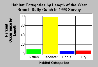
Habitat Frequency by LengthHabitat frequency can be used to roughly gauge problems of cumulative watershed effects on streams. When substantial erosion occurs in a watershed, pool habitats fill in (Madej, 1984). Subsequent habitat surveys will find the stream dominated by riffle habitats or shallow glides and runs. These flatwater habitats may still be suitable for young of the year steelhead, but young coho salmon require pools, preferably with large wood. Older age steelhead also rely on pool habitat (Chen, 1992).
KRIS Noyo shows habitat typing summaries that combine the 22 habitats into four broad categories for simpler analysis: pools, riffles, flat water habitats and dry areas. Habitat frequency by length is used instead of percent occurrence because streams that are aggraded (filled in) may still have a high number of pools that are short in length and a few very long runs and riffles.
 |
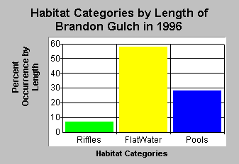 |
| The West Branch of Duffy Creek has a low pool frequency (<20%) and substantial reaches of dry habitat, indicating compromised fish habitat quality. | Brandon Gulch shows improved pool frequency (nearly 30%) and no dry habitats, reflecting better fish habitat. |
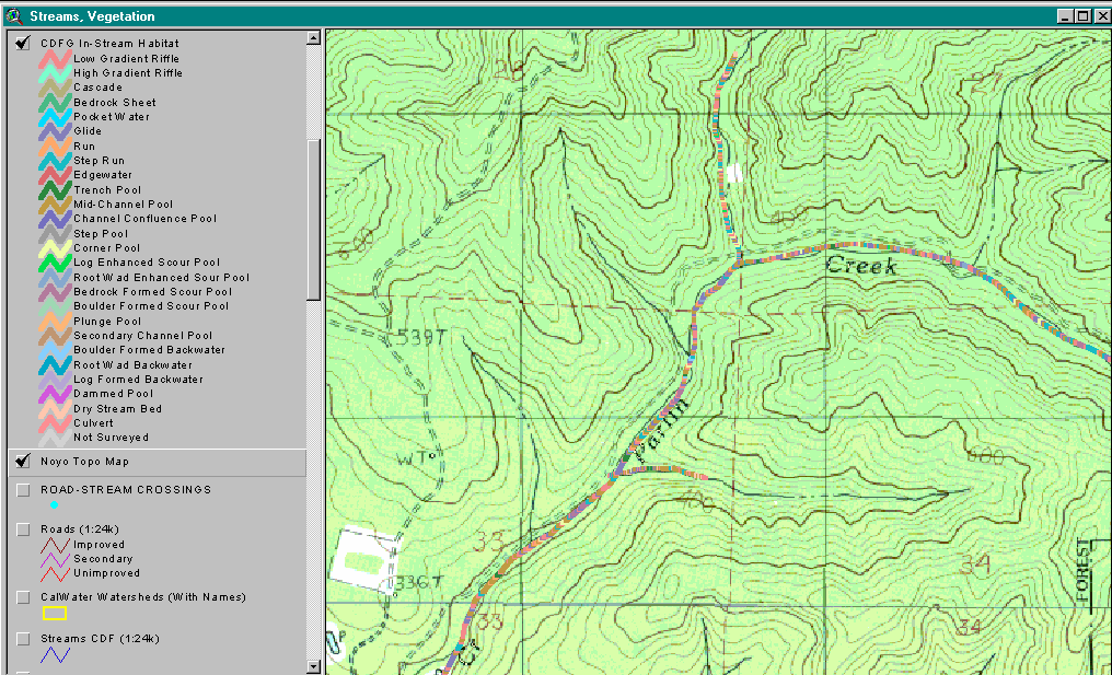 |
This image is from the KRIS Noyo Map project and shows a California Department of Fish and Game habitat typing map for Parlin Creek, a South Fork Noyo River tributary in Jackson Demonstration State Forest. Each habitat unit and its length was mapped in ArcView using dynamic segmentation (Byrne, 1997). The backdrop is a USGS topo map. |
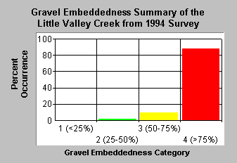
Embeddedness
Embeddedness scores in KRIS Noyo can be used as an indicator of salmonid spawning habitat quality. Pools tail crests are measured visually to see to what degree potential spawning gravels might be embedded (partially buried). The California Department of Fish and Game (1998) categorize gravels less than 25% embedded as optimal for salmonid spawning. Other categories are 25-50%, 50-75% and greater than 75%.
 |
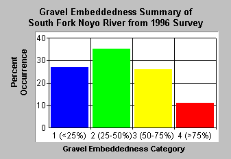 |
| KRIS Noyo shows that watersheds with more intensive management sometimes have spawning gravels with most embeddedness values greater than 75%. Little Valley Creek has both timber management and ranching as land use activities. | Watersheds with more moderate impacts such as the South Fork Noyo, which drains Jackson Demonstration State Forest, have gravels more suitable for salmonid spawning. |
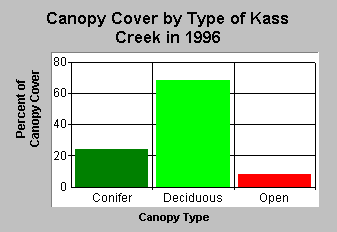
Canopy Cover
Canopy is an indicator of whether the cool microclimate necessary for moderating water temperatures is present and also whether there is a large wood supply for recruitment into the stream (Poole and Berman, 2000). Even if there is a high shade component, deciduous canopy cover may be less able to provide a cool microclimate over the stream than a multi-tiered coniferous over-story.
 |
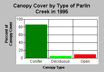 |
| Kass Creek has a high component of deciduous trees, 68%, and less than 30% conifers. The stream is likely to be deficient of large wood for a long duration. | Parlin Creek in Jackson Demonstration State Forest retains a substantial component of conifers and more than an 80% canopy overall. |
![]()
References
Byrne, M. 1997. California Salmonid Habitat Inventory: a Dynamic Segmentation Application. Earth Science Research Institute (ESRI), 1997 Annual Proceedings of ESRI Conference. CDFG, Inland Fisheries, Sacramento, CA.
CA Department of Fish and Game. 1998. California Salmonid Stream Habitat Restoration Manual. Third Edition. Inland Fisheries Division. California Department of Fish and Game. Sacramento, CA. 495 p.
Chen,G. 1992. Use of Basin Survey Data in Habitat Modeling and Cumulative Watershed Effects Analysis. Siskiyou NF. Published as part of USDA Forest Service Region 5 Fish Habitat Relationship Technical Bulletin Series, No. 8.
Madej, M. 1984. Recent changes in channel-stored sediment Redwood Creek, California. Redwood National Park Technical Report #11, Arcata, CA. 54 p.
Poole, G.C., and C.H. Berman. 2000. Pathways of Human Influence on Water Temperature Dynamics in Stream Channels. U.S. Environmental Protection Agency, Region 10. Seattle, WA. 20 p.
![]()
| www.krisweb.com |