
| Area | Lower Noyo/Basin-wide |
| Topic | Sediment: Matthew Road Construction by Period Basin Wide 1942-1999 |
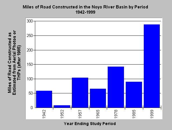
| Caption: The Chart above shows the miles of road constructed in the Noyo Basin by intervals in years shown on the X axis. Estimates were based on historic aerial photos, and in the case of the most recent interval, inclusion of roads constructed according to planned timber harvests as provided by the California Department of Forestry. Of 754 total miles of road miles, seasonal (dirt) roads were 83.7% of the total, followed by rocked road at 13.2%, paved at 1.9%, and highway at 1.2%. Data provided by and analysis patterned after Matthews (1999). Click on Picture to see Figure 34 from Matthews (1999), Sediment Source Analysis and Preliminary Sediment Budget for the Noyo River, by which data was provided and after which analysis patterned. | |
 |
To learn more about this topic click here .
To view the table with the chart's data, click Chart Table web page.
To download the table with the chart's data, click roadmiles42_99.dbf (size 252 bytes) .
To see meta information about the data table used for this topic click here
| www.krisweb.com |