
| Area | Lower Noyo/Basin-wide |
| Topic | Sediment: Matthews Road Densities All Noyo Basins |
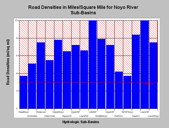
| Caption: The road density for various hydrologic sub-basins was calculated by Matthews from aerial photos and estimates from recent timber harvests. Densities in the whole Noyo River basins are 6.67 mi/sq mile, with some sub-basins at 10 miles of road per square mile. The Little North Fork and Lower South Fork Noyo have the highest road densities while the North Fork South Fork and Upper Noyo have the least.. The National Marine Fisheries Service (1996) published guidelines for maintaining properly functioning watershed conditions and noted that watersheds with more than 3 miles of road per square mile were not properly functioning. This value is shown as a refence above for comparison. Data provided by Matthews (1999): Sediment Source Analysis and Preliminary Sediment Budget for the Noyo River. Click on InfoLinks for more background information. See Picture for map images. | |
 |
To learn more about this topic click here .
To view the table with the chart's data, click Chart Table web page.
To download the table with the chart's data, click roaddensity.dbf (size 1,106 bytes) .
To see meta information about the data table used for this topic click here
| www.krisweb.com |