
| Area | Lower Noyo/Basin-wide |
| Topic | Timber Harvest: Matthews Noyo Basin Wide 1933-1999 |
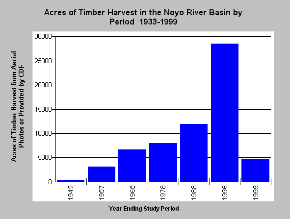
| Caption: The Chart above shows the number of acres logged in the intervals ending with the year shown on the X axis. Timber harvests were estimated from aerial photos for earlier intervals. Aerial photos were used in combination with timber harvest plans filed with the California Department of Forestry in more recent periods. Timber harvests showing in the 1942 aerial were estimated to have been conducted within the previous 10 years. Timber harvests steadily increased through 1996 in the Noyo Basin. Data provided by and analysis patterned after Matthews (1999): Sediment Source Analysis and Preliminary Sediment Budget for the Noyo River. | |
 |
To learn more about this topic click here .
To view the table with the chart's data, click Chart Table web page.
To download the table with the chart's data, click sumthpby_period.dbf (size 231 bytes) .
To see meta information about the data table used for this topic click here
| www.krisweb.com |