| Area |
Middle Noyo |
| Topic |
Tour: Little North Fork & Middle Noyo Aerial Photos |
 Click on image to enlarge (161K).
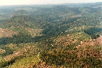
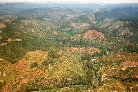
Aerial view of Noyo River watershed looking W from about 15 mi. E of Fort Bragg, which is barely visible near top edge center (see steam plume from mill). Note dead standing trees lower right; Noyo River riparian corridor and Skunk track from left to center in the photo. DME30.6@312; near Northspur; June 5, 1990, Roll L frame 36, on Kodak Ektar 25 negative film, Photo by Nicholas Wilson. Scanned from 4x6@200 on 3/28/00.
 Click on image to enlarge (155K).
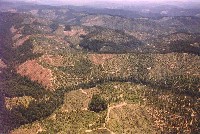
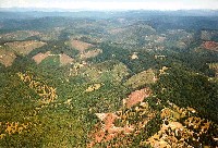
Redwood clearcuts covering over 20 sq. mi. near Ft. Bragg, CA. Cumulative effect of over 50 separate logging operations mostly completed between 1985 and 1990. View looking easterly, with top end of Pudding Creek near upper left corner and running along left edge, then curving across lower middle of picture, following narrow strip of trees. Little North Fork Noyo basin is just above the middle ridge line, and shown nearly in entirety, with main Noyo behind. The line near the top where trees remain is the boundary of Jackson State. Aerial photo by Nicholas Wilson, 1990, frame L-31.
 Click on image to enlarge (221K).
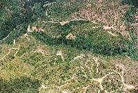
Aerial view of Noyo River and Hayshed Gulch, three miles east-southeast of Fort Bragg, looking east. Skunk train tracks and the mainstem Noyo River corridor is visible at left. Riparian zone protects Class II stream. June 5, 1990, Roll L frame 16, on Kodak Ektar 25 negative film, Photo by Nicholas Wilson. Scanned from 4x6@200 on 3/28/00.
 Click on image to enlarge (177K).
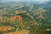
Aerial view of Noyo River at confluence of the South Fork from a point about 3 miles southeast of Fort Bragg, looking east. Skunk train tracks and the mainstem Noyo River are visible at curve lower left. The Kass Creek watershed is the center right area of the photo and Kass Creek joins the South Fork just upstream. Jackson Demonstration State Forest is uncut area at right. June 5, 1990, Roll L frame 17, on Kodak Ektar 25 negative film, Photo by Nicholas Wilson. Scanned from 4x6@200 on 3/28/00.
 Click on image to enlarge (182K).
Aerial view of Noyo River from a point about 2 miles southeast of Fort Bragg, looking east. Skunk train tracks and mainstem Noyo River visible inside curve at lower right, at Hayshed Gulch. South Fork Noyo River comes in from right at curve just below right center. Mostly GP land. The edge of the Brandon Gulch CalWater watershed within Jackson Demonstration State Forest is visible at upper right bordering Kass Creek. June 5, 1990, Roll L frame 19, on Kodak Ektar 25 negative film, Photo by Nicholas Wilson. Scanned from 4x6@200 on 3/28/00.
 Click on image to enlarge (166K).
Aerial view of Pudding Cr. and Noyo River looking east-northeast from about 1.5 miles east of Fort Bragg. Residential area along Sherwood Rd. at lower right corner. Site of Glen Blair on flat just left of center. Noyo watershed to right and above center. Jackson Demonstration State Forest visible to the south as contiguous line of older trees (at right in distance). June 5, 1990, Roll L frame 24, on Kodak Ektar 25 negative film, Photo by Nicholas Wilson. Scanned from 4x6@200 on 3/28/00.

 Click on image to enlarge (161K).
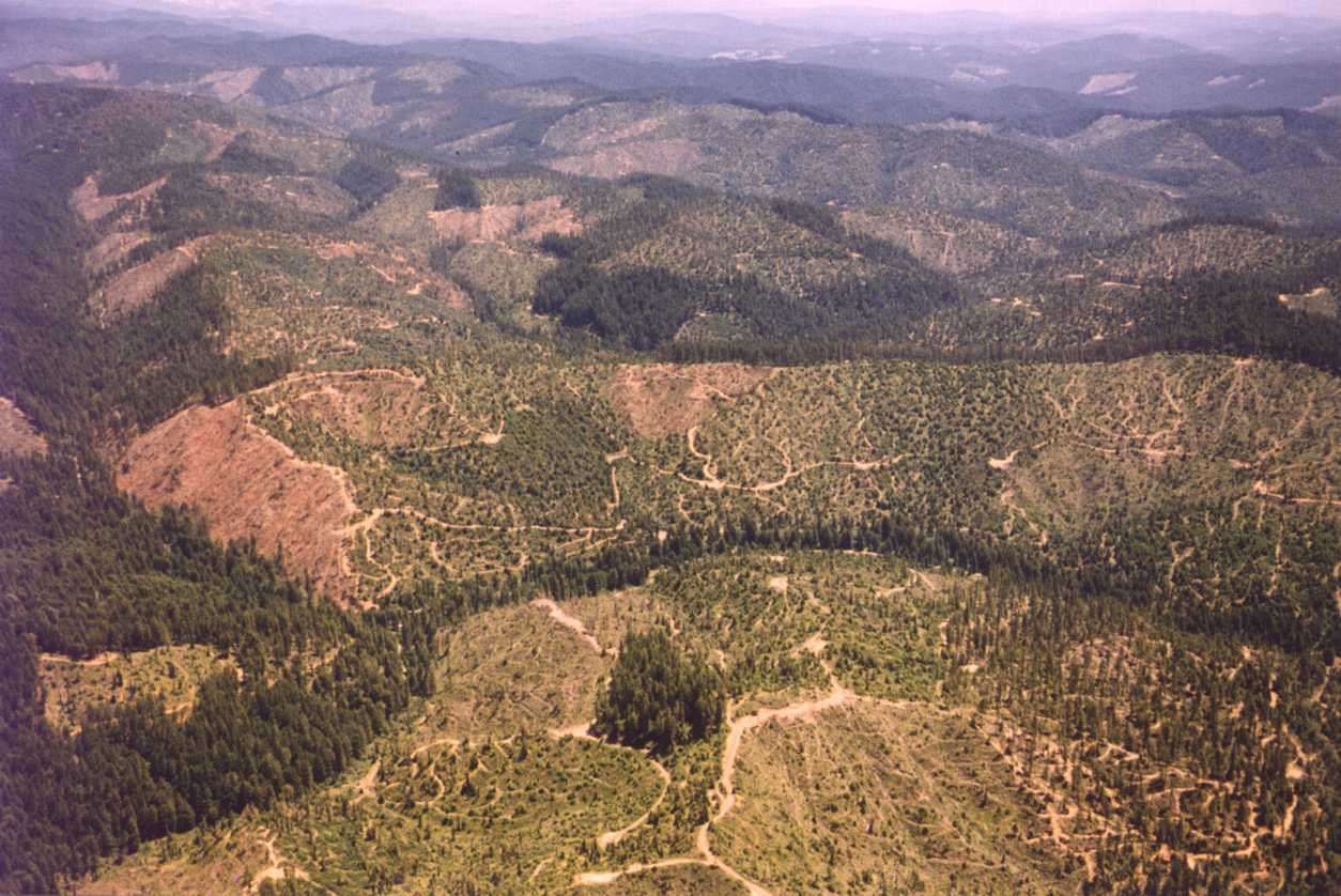 Click on image to enlarge (155K).
 Click on image to enlarge (221K).
 Click on image to enlarge (177K).
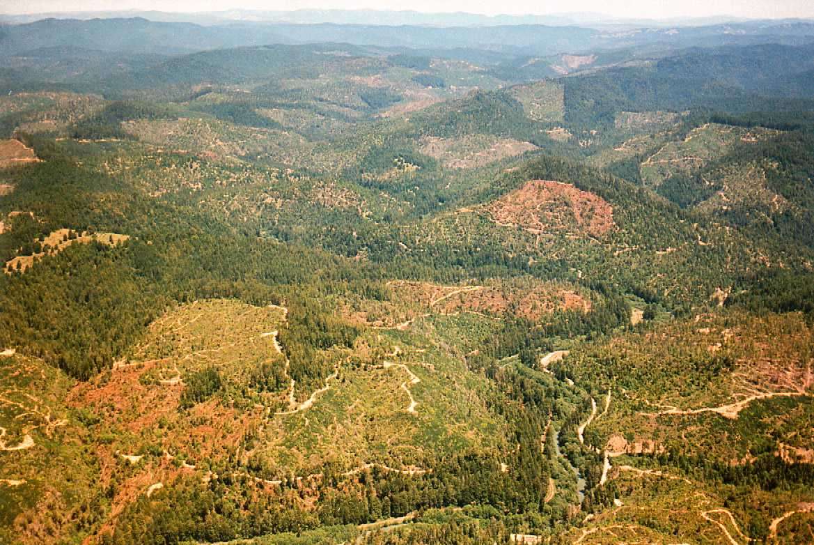 Click on image to enlarge (182K).
 Click on image to enlarge (166K).