
| Area | South Fork |
| Topic | Habitat Typing: Kass Creek Percent by Length |
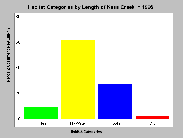
| Caption: The chart above shows percent occurrence by length of three habitat categories taken from a habitat typing survey in July 1996, which covered 15,990 feet or 3 miles. Dominance of flatwater habitats (62%) and occurrence of reaches that run sub-surface (dry 2%) suggest that intensive silviculture in the period prior to the survey may have triggered erosion, sediment yield to the channel, and sediment deposition which filled in pools. Pool frequency by length on Kass Creek was 27%, which is somewhat higher than Duffy Gulch, and the Little NF Noyo. The upper reaches of the habitat survey were confined reaches with high sediment transport capability (Rosgen B-4 channel type) which would facilitate pool rejuvenation from sediment impacts. Data collected by Georgia Pacific and supplied for use in KRIS by the California Department of Fish and Game, Sacramento, CA. Click on the InfoLinks tab to review the habitat typing report. | |
 |
To learn more about this topic click here .
To view the table with the chart's data, click Chart Table web page.
To download the table with the chart's data, click kasshabtypelength.dbf (size 202 bytes) .
To see meta information about the data table used for this topic click here
To view the table with the chart's source data, click Source Table web page.
To download the table with the chart's source data, click kass.dbf (size 91,970 bytes)
| www.krisweb.com |