
| Area | South Fork |
| Topic | Sediment: Road Densities South Fork Noyo Sub-Basins |
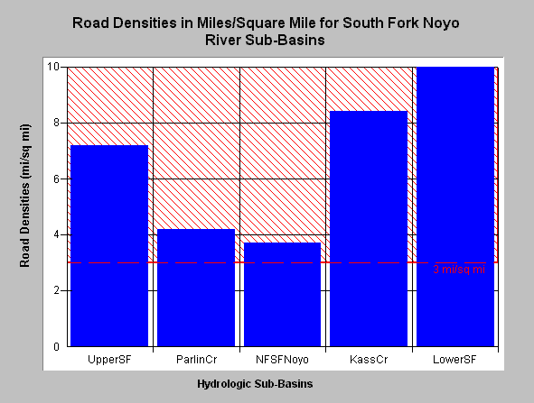
| Caption: The road density in the South Fork Noyo River sub-basin ranged from 3.7 to 10 miles per square mile as estimated by Matthews (1999). Studies in Washington State (Cedarholm et al., 1981) found that fine sediment in salmon redds increased as road densities exceeded 3 miles of road per square mile of landscape. This density is shown as a threshold for comparison on the bar graph above. Data provided by Matthews (1999): Sediment Source Analysis and Preliminary Sediment Budget for the Noyo River. Click on Picture to see a map of roads in the South Fork Noyo sub-basin and an area map. Click on InfoLinks for more background information. | |
 |
To learn more about this topic click here .
To view the table with the chart's data, click Chart Table web page.
To download the table with the chart's data, click roaddensitysf.dbf (size 435 bytes) .
To see meta information about the data table used for this topic click here
| www.krisweb.com |