
| Area | South Fork |
| Topic | Temperature: Min, Max and Average at SF Noyo (Lower/site 16) 1996 |
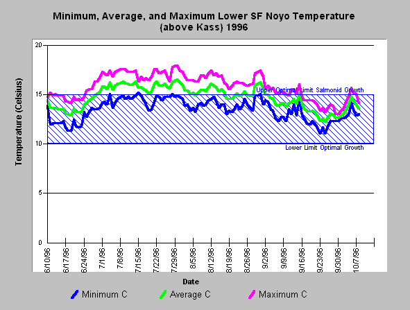
| Caption: The chart above shows the minimum, maximum and average water temperature of the lowermost South Fork Noyo River site above Kass Creek (site 16) during the summer of 1996. Water temperatures peaked at ~17.6 C in late July, and ~18 C in late July 1996 with a diurnal temperature shift of ~3 C. Data provided by Jackson Demonstration State Forest. Click on Picture to see a map of temperature monitoring locations. See InfoLinks or Temperature Background page to find information on threshold listed. | |
 |
To learn more about this topic click here .
To view the table with the chart's data, click Chart Table web page.
To download the table with the chart's data, click sfn1696mma.dbf (size 8,511 bytes) .
To see meta information about the data table used for this topic click here
To view the table with the chart's source data, click Source Table web page.
To download the table with the chart's source data, click sfnoyostrm_temps.dbf (size 3,997,861 bytes)
| www.krisweb.com |