
| Area | South Fork |
| Topic | Temperature: Min, Max and Average at SF Noyo (site 12) 1996 |
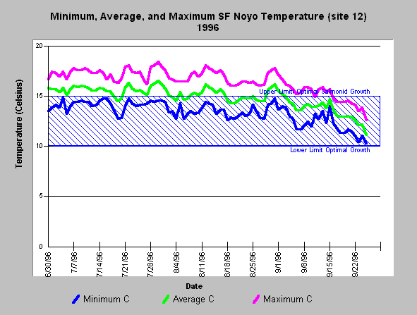
| Caption: The chart above shows the minimum, maximum and average water temperature of the South Fork Noyo River below Bear Gulch (site #12) during the summer of 1996. Maximum and average temperatures exceeded the optimal range for salmonid growth regularly in July and August. Water temperatures peaked at ~18.5 C in late July 1996 with a diurnal temperature shift of ~4 C. Data provided by Jackson Demonstration State Forest. Click on Picture to see a map of temperature monitoring locations. See InfoLinks for more information on data collection and a link to discussions on thresholds used in the KRIS Noyo project. | |
 |
To learn more about this topic click here .
To view the table with the chart's data, click Chart Table web page.
To download the table with the chart's data, click sfn1296mma.dbf (size 6,234 bytes) .
To see meta information about the data table used for this topic click here
To view the table with the chart's source data, click Source Table web page.
To download the table with the chart's source data, click sfnoyostrm_temps.dbf (size 3,997,861 bytes)
| www.krisweb.com |