
| Area | Upper Noyo |
| Topic | USFS VegTypes: Olds Creek CalWater 1994 |
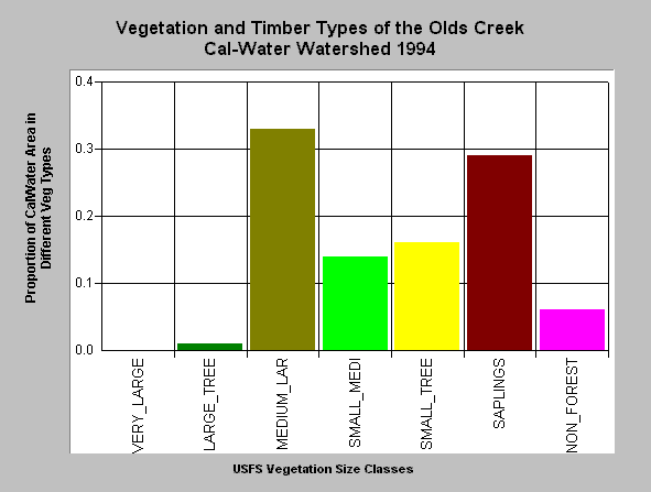
| Caption: This bar chart shows vegetation and timber types of the Olds Creek Calwater planning watershed. The information was derived from a 1994 Landsat image by the U.S. Forest Service. This analysis technique calculates averages of vegetation stands and is not accurate at the pixel (30 meter) level. Scroll down for a key to classifications. The Olds Creek Calwater was dominated by medium-large trees (20"-29.9") as of 1994 with this size class comprising 33% of the watershed but also retained 1% very large trees large trees (>40" diameter) and 4% large trees (30-39.9" diameter). Small to medium sized trees (12-19.9" diameter) made up 14% of the watershed, small trees 16% (5-11.9" diameter), 29% saplings (1-4.9" diameter) and 6% non-forest. Click on Picture to see an ArcView scene of the Olds Creek Calwater planning watershed showing vegetation types. Vegetation classifications are: VLargeTree = >40" in diameter LargeTree = Trees 30-39.9" in diameter Medium/Large Trees = 20-29.9" in diameter Small/Medium Trees = 12-19.9" in diameter Small Trees = 5-11.9" in diameter Non-Forest = No trees, shrubs, grass, bare soil | |
 |
To learn more about this topic click here .
To view the table with the chart's data, click Chart Table web page.
To download the table with the chart's data, click usfspercent.dbf (size 6,182 bytes) .
To see meta information about the data table used for this topic click here
To view the table with the chart's source data, click Source Table web page.
To download the table with the chart's source data, click veg_mndopercent.dbf (size 14,792 bytes)
| www.krisweb.com |