
| Area | General |
| Topic | Sediment: Average Road Densities in Redwood Creek Sub-Basins |
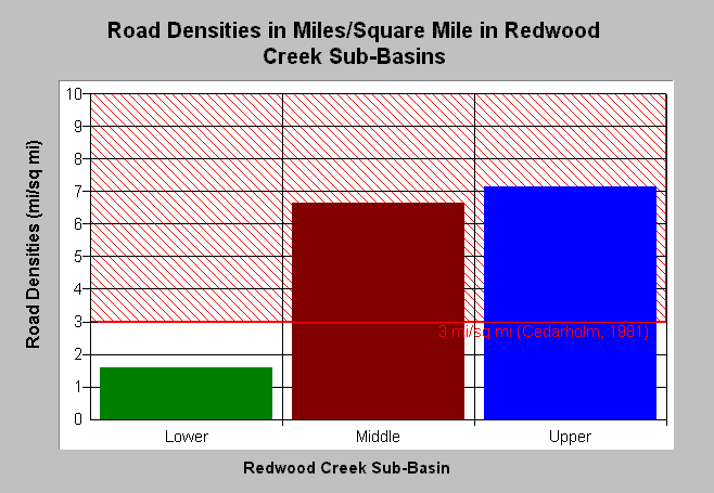
| Caption: This chart shows road density (mi/sq mi) for Redwood Creek NCWAP sub-basins. Roads density is relatively high in the Middle and Upper Redwood sub-basins, exceeding the 3-mi/sq mi reference line. Studies in Washington State (Cedarholm, 1981) found that fine sediment in salmon redds increased as road densities exceeded 3 miles of road per square mile of landscape. The Lower sub-basin only contains road data on a 24-square mile portion of the 69.5 sq mi sub-basin. Data are provided by Redwood National Park. The Picture tab show GIS images of roads in the Redwood Creek basin. Click on Info Links for more background information. | |
 |
To learn more about this topic click Info Links .
To view a table of information about this data click Metadata .
To view the table with the chart's data, click Chart Table web page.
To download the table with the chart's data, click rc_road_sub_sum.dbf (size 495 bytes) .
To view the table with the chart's source data, click Source Table web page.
To download the table with the chart's source data, click rc_road_source.dbf (size 12,915 bytes)
| www.krisweb.com |