
| Area | General |
| Topic | Sediment: Streambed Elevation Change, Middle Redwood Creek |
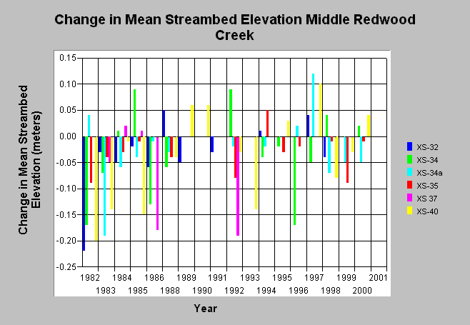
| Caption: This chart shows the change in mean streambed elevation in Middle Redwood Creek by year. Cross-sections (XS) are shown downstream to upstream, left to right. The change in mean streambed elevation is determined relative to the previous measure of mean streambed elevation at the same cross-section. For example, the first year shown, 1982, is relative to measurements taken in 1981. The data spans from 1982 to 2001. Scour is mainly observed at Middle Redwood Creek sites. See Picture for a figure containing cross-section locations. These data are from Redwood National Park. See Info links for more information. | |
 |
To learn more about this topic click Info Links .
To view a table of information about this data click Metadata .
To view the table with the chart's data, click Chart Table web page.
To download the table with the chart's data, click xs_ec_rdwd_cross1.db (size 16,384 bytes) .
To view the table with the chart's source data, click Source Table web page.
To download the table with the chart's source data, click xs_ec_rdwd_source.dbf (size 15,810 bytes)
| www.krisweb.com |