
| Area | Middle Redwood |
| Topic | USFS Riparian VegTypes: Lower Lacks Creek 1994 |
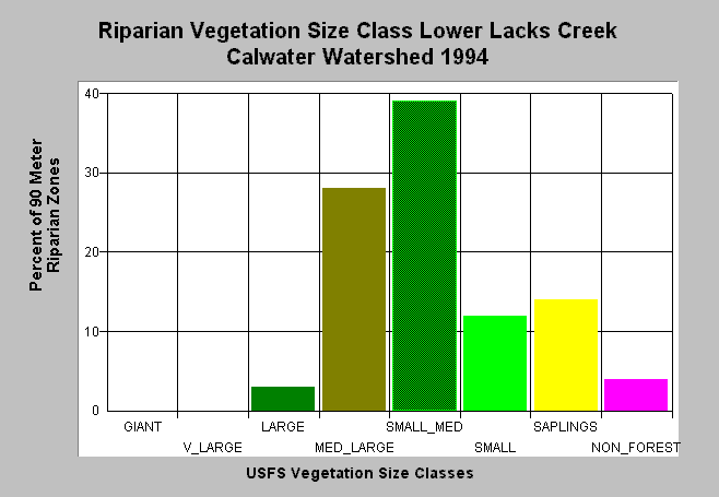
| Caption: This bar chart shows riparian vegetation size classes for Lower Lacks Creek in the Middle Redwood Creek sub-basin. Riparian vegetation is considered to be 90-meters (300 feet) on either side of the channel. This planning watershed had 31% of the riparian in medium-large and greater trees, 65% in small-medium and smaller trees and 4% in non-forest as of 1994. Click on Picture to see an ArcView screen print of the Calwater planning watershed showing riparian vegetation class size. The information was derived from a 1994 Landsat image by the U.S. Forest Service. Vegetation is classified according to diameter at breast height (DBH): Giant = >50" DBH, V Large = 40-50" DBH, Large = 30-39.9" DBH, Medium/Large = 20-29.9" DBH, Small/Medium = 12-19.9" DBH, Small = 5-11.9" DBH, Non-Forest = No trees, shrubs, grass, bare soil. This analysis technique calculates averages of vegetation stands and more accurate at the stand rather than tree level. See Info Links for more information. | |
 |
To learn more about this topic click Info Links .
To view a table of information about this data click Metadata .
To view the table with the chart's data, click Chart Table web page.
To download the table with the chart's data, click riparian_usfs.dbf (size 3,906 bytes) .
| www.krisweb.com |