
| Area | Middle Redwood |
| Topic | USFS Riparian VegTypes: Middle Redwood Creek Sub-Basin Average 1994 |
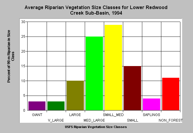
| Caption: This bar chart shows riparian tree size classes of the Lower Redwood Creek sub-basin averaged from all the Calwater Planning Watersheds in the sub-basin. Lower Redwood Creek sub-basin had 41% of the riparian in medium-large and greater trees, 48% in small-medium and smaller trees and 11% in non-forest as of 1994. The information was derived from a 1994 Landsat image by the U.S. Forest Service. This analysis technique calculates averages of vegetation stands and is not accurate at the pixel (30 meters) level. Scroll down for a key to classifications. Click on Picture to see an ArcView scene of the May Creek Calwater planning watershed showing riparian vegetation class size. Vegetation is classified according to diameter at breast height (DBH): Giant = >50" DBH, V Large = 40-50" DBH, Large = 30-39.9" DBH, Medium/Large = 20-29.9" DBH, Small/Medium = 12-19.9" DBH, Small = 5-11.9" DBH, Non-Forest = No trees, shrubs, grass, bare soil. | |
 |
To learn more about this topic click Info Links .
To view a table of information about this data click Metadata .
To view the table with the chart's data, click Chart Table web page.
To download the table with the chart's data, click riparian_usfs.dbf (size 3,906 bytes) .
| www.krisweb.com |