
| Area | Prairie Creek |
| Topic | Sediment: V* From Little Lost Man Creek, 1992-2001 |
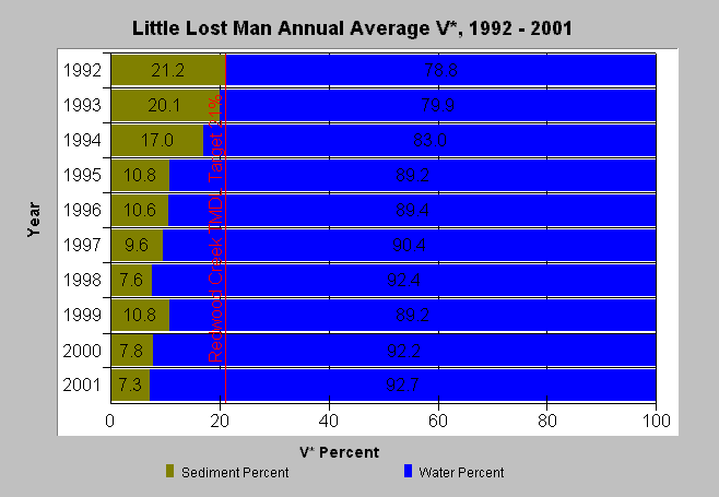
| Caption: This chart illustrates that V* in Little Lost Man Creek has been consistently under the TMDL target of 21% since 1993. There has been no active management in Little Lost Man Creek during this period, so the decrease in V* could be due to watershed rest. Click on the Picture Tab to see the sampling locations and a map of roads in the sub-basin. Little Lost Man Creek has one of the lowest road densities in the entire Redwood Creek basin. Data are provided by the U.S. Forest Service, Redwood Sciences Lab. See Info Links for more details. See the source table for individual year data and standard error. | |
 |
To learn more about this topic click Info Links .
To view a table of information about this data click Metadata .
To view the table with the chart's data, click Chart Table web page.
To download the table with the chart's data, click vstar_llm.dbf (size 1,464 bytes) .
To view the table with the chart's source data, click Source Table web page.
To download the table with the chart's source data, click vstar_llm_source.dbf (size 44,090 bytes)
| www.krisweb.com |