
| Area | Basinwide/General |
| Topic | Fish: Vertebrate Species Richness by Sub-Basin, 1995-1998 |
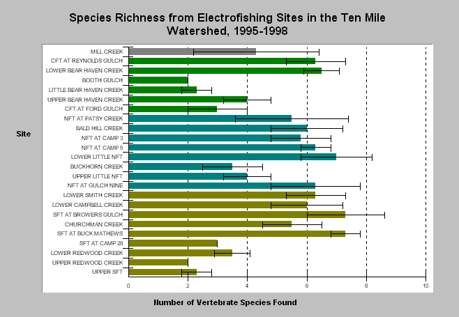
| Caption: The number of species captured during electrofishing varied among 24 sites within the Ten Mile River watershed, as shown by the bar chart above. Middle Fork sites are in green, North Fork sites in blue, South Fork sites in brown. The chart's error bars show +/- one standard deviation. Variation among years was greatest for Mill Creek (TEN1) where two species were captured in 1996, and seven species captured in 1998. The lowest mean species richness occurred at Lower Bear Haven Creek (CFT3) and Upper Redwood Creek (SFT8) where only steelhead trout and Pacific Giant Salamanders were captured. The highest species richness occurred at South Fork at Brower's Gulch (SFT3) where 9 species were captured in 1997. Data provided by the Hawthorne Timber Company (former Georgia-Pacific). Click on Picture for a map of locations. Click on Info Links for more information. | |
 |
To learn more about this topic click here .
To view the table with the chart's data, click Chart Table web page.
To download the table with the chart's data, click vert_rich.dbf (size 2,642 bytes) .
To see meta information about the data table used for this topic click here
| www.krisweb.com |