
| Area | Basinwide/General |
| Topic | Sediment: Matthews Road Construction Lower Ten Mile Basin 1933-1999 |
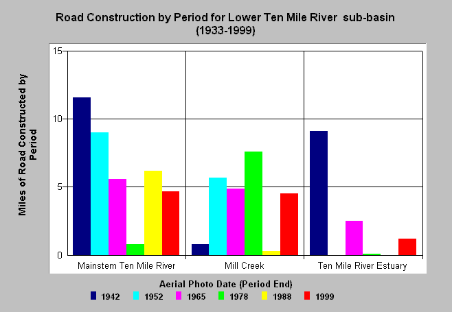
| Caption: The chart above shows the miles of road construction by period for Lower Ten Mile River sub-basins. The greatest period of road construction in the lower mainstem Ten Mile and areas adjacent to the estuary were prior to 1942 and included a railroad. The Mill Creek watershed had its highest period of construction between 1965 and 1978. Estimates are generated largely from aerial photos and years shown above are the year of the photo used and cover the period back to the previous photo year. Matthews Associates (2000) state: "Prior to 1988, the history was developed primarily from interpretation of aerial photography. From 1988 to present, road and harvest history was obtained from CDF GIS coverages which had been developed by directly inputting information provided as part of submitted Timber Harvest Plans (THPs)." See Info Links for more background information and links to references. | |
 |
To learn more about this topic click here .
To view the table with the chart's data, click Chart Table web page.
To download the table with the chart's data, click lower10roads.dbf (size 2,294 bytes) .
To see meta information about the data table used for this topic click here
| www.krisweb.com |