
| Area | Basinwide/General |
| Topic | Sediment: Matthews Road Densities All Ten Mile River Sub-Basins |
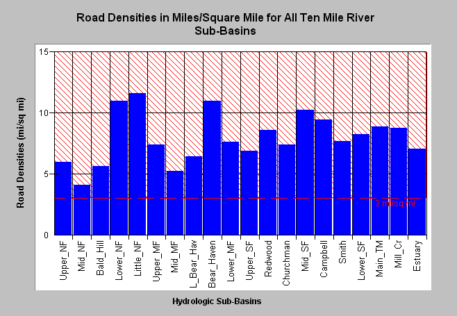
| Caption: Road densities in miles per square mile are shown above for all Ten Mile River sub-basins as estimated by Matthews (2000) with the overall road density for the entire watershed calculated at 7.86 miles/square mile. Densities all exceed properly functioning condition according to the National Marine Fisheries Service (1996) which is less than 3 miles per square mile, a value shown for reference above. The lowest road densities are found in the Middle North Fork basin (4.11 mi/sq mi) and the highest are in the Little North Fork (11.41 mi/sq mi). Click on Picture to see a map of each sub-basin. This value is shown for reference above. Data provided by Matthews (1999): Sediment Source Analysis and Preliminary Sediment Budget for the Noyo River. Click on Info Links for more background information. | |
 |
To learn more about this topic click here .
To view the table with the chart's data, click Chart Table web page.
To download the table with the chart's data, click matthewstenroads.dbf (size 2,170 bytes) .
To see meta information about the data table used for this topic click here
| www.krisweb.com |