
| Area | Basinwide/General |
| Topic | Sediment: Matthews Sediment Landslides by Land Use 1933-1999 |
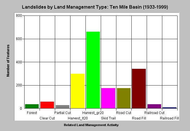
| Caption: The chart above shows the antecedent land management associated with landslides identified from aerial photographs in the Ten Mile River basin. Data comes from Matthews and Associates (2000) and is derived from aerial photographs from 1942, 1952, 1965, 1978, 1988 and 1999. Only 36 landslides occurred in undisturbed forest lands (Forest). The highest number of slides (660) occurred more than 20 years after timber harvest (Harvest_gr20) but a substantial number (300) also happened on slopes cut less than 20 years ago (Harvest_lt20). Road fills caused 340 debris slides, some of which were failed crossings during major storm events. While railroads triggered only 37 landslides, they may have contributed to more before the period of aerial photo reconnaissance. The railroads were operated from 1910 to 1950. Click on Info Links for more information. | |
 |
To learn more about this topic click here .
To view the table with the chart's data, click Chart Table web page.
To download the table with the chart's data, click slidemgmnt.dbf (size 348 bytes) .
To see meta information about the data table used for this topic click here
| www.krisweb.com |