
| Area | Basinwide/General |
| Topic | Timber Harvest: Matthews By Large Basin (Percent) 1933-1999 |
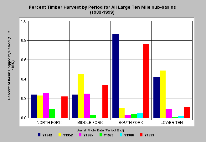
| Caption: The chart above shows the percentage of all large Ten Mile River Planning Watersheds logged by period according to estimates by Matthews and Associates (2000). The South Fork watershed has the highest percentage of area logged with 87% prior to 1942 and 76% between 1988 and 1999. Estimates are generated largely from aerial photos and years shown above are the year of the photo used and cover the period back to the previous photo year. The 1942 aerial photos were thought to estimate harvest as far back as 1933. Matthews Associates (2000) state: "Prior to 1988, the history was developed primarily from interpretation of aerial photography. From 1988 to present, road and harvest history was obtained from CDF GIS coverages which had been developed by directly inputting information provided as part of submitted Timber Harvest Plans (THPs)." See Info Links for more background information and links to references. Click the Picture tab for related map images and charts taken from Matthews (2000). | |
 |
To learn more about this topic click here .
To view the table with the chart's data, click Chart Table web page.
To download the table with the chart's data, click thp42_99pw.dbf (size 1,142 bytes) .
To see meta information about the data table used for this topic click here
| www.krisweb.com |