
| Area | Lower Ten Mile |
| Topic | Sediment: Fines <0.85 mm from Mill Cr (Ten1) 1993-2000 |
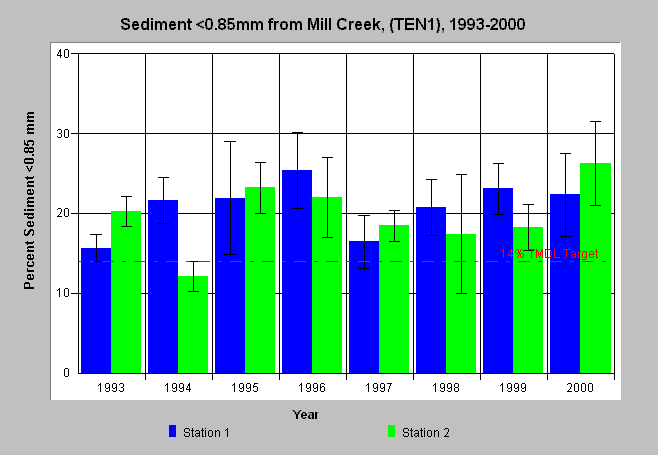
| Caption: The chart above shows the percent fine sediment less than 0.85 mm for 1993-2000 from wet sieve McNeil bulk gravel samples in Mill Creek (TEN1) in the Lower Ten Mile River basin. Two stations (riffles) were sampled annually. Bars represent the average of four McNeil cores at a station and whiskers represent standard deviation (95% confidence interval since the sample size is four). The range of fine sediment was above levels recognized as impairing salmonid egg and alevin survival in some years, which is reflected by the reference value of 14% from the Ten Mile River TMDL. Data provided by Hawthorne Timber Company. See Info Links for more information. | |
 |
To learn more about this topic click here .
To view the table with the chart's data, click Chart Table web page.
To download the table with the chart's data, click mcneil_ten1_85.db (size 4,096 bytes) .
To see meta information about the data table used for this topic click here
To view the table with the chart's source data, click Source Table web page.
To download the table with the chart's source data, click mcneil_source_ten.dbf (size 414,612 bytes)
| www.krisweb.com |