
| Area | Lower Ten Mile |
| Topic | Sediment: Matthews Road Densities Lower Ten Mile River Sub-Basins |
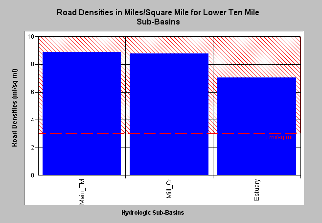
| Caption: Road densities as estimated by Matthews (2000) for Lower Ten Mile River sub-basins are shown above in miles per square mile. Densities all exceed properly functioning condition according to the National Marine Fisheries Service (1996), which is less than 3 miles per square mile, the value shown for reference. According to Matthews (2000): "The Lower Ten Mile Planning Watershed has the highest road density (8.46 mi/sq mi) of the four planning watersheds." The road densities range from 7.05 mi/sq mi in the estuary sub-basin to 8.87 mi/sq mi in the lower Main Ten Mile sub-basin. Click on Picture to see a map of roads in the Lower Ten Mile sub-basin. Click on Info Links for more background information. | |
 |
To learn more about this topic click here .
To view the table with the chart's data, click Chart Table web page.
To download the table with the chart's data, click lowertenmattroads.dbf (size 1,894 bytes) .
To see meta information about the data table used for this topic click here
| www.krisweb.com |