
| Area | Middle Fork Ten Mile |
| Topic | USFS VegTypes: Booth's Gulch Calwater 1994 |
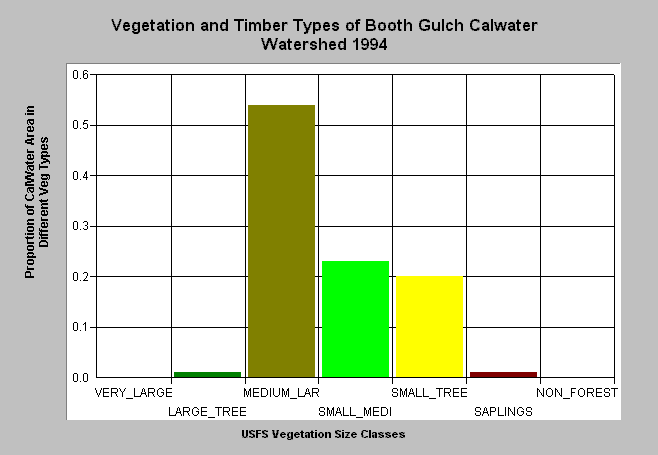
| Caption: This bar chart shows vegetation and timber types of the Bear Haven Calwater planning watershed in the Middle Fork Ten Mile River basin. The information was derived from a 1994 Landsat image by the U.S. Forest Service. This analysis technique calculates averages of vegetation stands and is not accurate at the pixel (30 meter) level. The Bear Haven watershed has is comprised of 41% Medium-Large Trees (20-29"), 23% Small-Medium Trees (12-19.9") and 2% Large Trees (30-39.9"). The remaining 21% of the watershed is in trees smaller than twelve inches. Click on Picture to see an ArcView scene of this Calwater planning watershed showing vegetation types. Vegetation classifications are: VLargeTree = >40" in diameter LargeTree = Trees 30-39.9" in diameter Medium/Large Trees = 20-29.9" in diameter Small/Medium Trees = 12-19.9" in diameter Small Trees = 5-11.9" in diameter Non-Forest = No trees, shrubs, grass, bare soil | |
 |
To learn more about this topic click here .
To view the table with the chart's data, click Chart Table web page.
To download the table with the chart's data, click tenvegsummchart.dbf (size 2,622 bytes) .
To see meta information about the data table used for this topic click here
To view the table with the chart's source data, click Source Table web page.
To download the table with the chart's source data, click vegsummstat.dbf (size 14,792 bytes)
| www.krisweb.com |