
| Area | Middle Fork Ten Mile |
| Topic | Sediment: Fines <6.4 mm (CFT 5) Booth Gulch 1993-2001 |
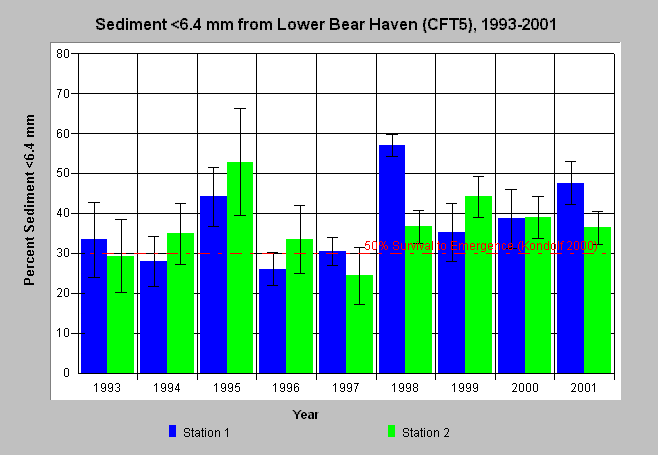
| Caption: Percent sediment less than 6.4 mm from McNeil samples in Booth Gulch (CFT 5) in the Middle Fork Ten Mile River are displayed above for the years 1993 to 2001. Two stations (riffles) in a study reach were sampled annually. Bars represent the average of four McNeil samples at a station and whiskers represent standard deviation and 95% confidence intervals. Sand and small gravel (<6.4 mm) were over levels known to impair salmonid survival in several years, including the range of all samples in 1995, 1998, 2000 and 2001. Reference line is from Kondolf (2000) who reported 30% <6.4 mm corresponding to 50% emergence of salmonids. The 6.4 mm results shown here were interpolated from 4 mm and 8 mm data provided by Hawthorne Timber Company. See Info Links for more information. | |
 |
To learn more about this topic click here .
To view the table with the chart's data, click Chart Table web page.
To download the table with the chart's data, click mcneil_cft3_64.db (size 4,096 bytes) .
To see meta information about the data table used for this topic click here
To view the table with the chart's source data, click Source Table web page.
To download the table with the chart's source data, click mcneil_source_ten.dbf (size 414,612 bytes)
| www.krisweb.com |