
| Area | North Fork Ten Mile |
| Topic | USFS VegTypes: Little NF Ten Mile Calwater 1994 |
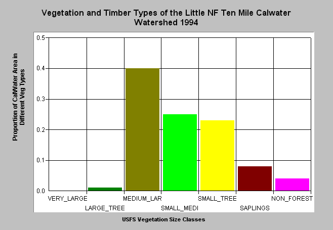
| Caption: This bar chart shows vegetation and timber types of the Little North Fork Calwater planning watershed, which covers part of the lower North Fork Ten Mile River drainage. The information was derived from a 1994 Landsat image by the U.S. Forest Service. This analysis technique calculates averages of vegetation stands and is not accurate at the pixel (30 meter) level. Scroll down for a key to classifications. The Little North Fork Calwater was dominated by Medium-Large trees (20-30" diameter), but maintained only 1% cover in Large Trees (30-40"). Small-Medium trees (12-19.9") trees constituted 25% of the watershed and 35% of the watershed was in early seral conditions as signified by Small Trees (6-11.9"), Saplings (1-4.9" diameter) and Non-Forest. Click on Picture to see an ArcView scene of the Little NF Calwater planning watershed showing vegetation types. Vegetation classifications are: VLargeTree = >40" in diameter LargeTree = Trees 30-39.9" in diameter Medium/Large Trees = 20-29.9" in diameter Small/Medium Trees = 12-19.9" in diameter Small Trees = 5-11.9" in diameter Non-Forest = No trees, shrubs, grass, bare soil | |
 |
To learn more about this topic click here .
To view the table with the chart's data, click Chart Table web page.
To download the table with the chart's data, click tenvegsummchart.dbf (size 2,622 bytes) .
To see meta information about the data table used for this topic click here
To view the table with the chart's source data, click Source Table web page.
To download the table with the chart's source data, click vegsummstat.dbf (size 14,792 bytes)
| www.krisweb.com |