
| Area | North Fork Ten Mile |
| Topic | USFS VegTypes: Patsy Creek (upper NF Ten Mile River) Calwater 1994 |
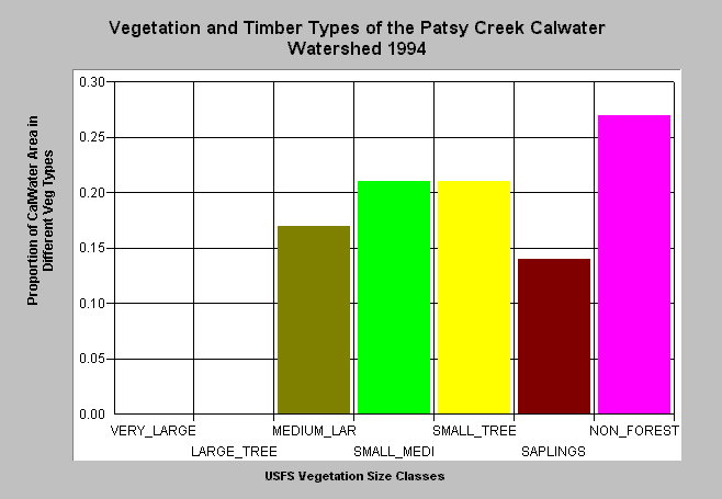
| Caption: This bar chart shows vegetation and timber types of the Patsy Creek Calwater planning watershed, which covers the upper North Fork Ten Mile River basin. The information was derived from a 1994 Landsat image by the U.S. Forest Service. This analysis technique calculates averages of vegetation stands and is not accurate at the pixel (30 meter) level. Scroll down for a key to classifications. The Patsy Creek Calwater has a much different signature than most other North Fork Ten Mile watersheds because it has extensive, natural grasslands in upland areas. These are partly linked to underlying bedrock geology and are likely indicative of interior belt Franciscan Formation. Click on Picture to see an ArcView scene of the Patsy Creek Calwater planning watershed showing vegetation types. Vegetation classifications are: VLargeTree = >40" in diameter LargeTree = Trees 30-39.9" in diameter Medium/Large Trees = 20-29.9" in diameter Small/Medium Trees = 12-19.9" in diameter Small Trees = 5-11.9" in diameter Non-Forest = No trees, shrubs, grass, bare soil | |
 |
To learn more about this topic click here .
To view the table with the chart's data, click Chart Table web page.
To download the table with the chart's data, click tenvegsummchart.dbf (size 2,622 bytes) .
To see meta information about the data table used for this topic click here
To view the table with the chart's source data, click Source Table web page.
To download the table with the chart's source data, click vegsummstat.dbf (size 14,792 bytes)
| www.krisweb.com |