
| Area | North Fork Ten Mile |
| Topic | Sediment: Fines <0.85 mm from (NFT 1) NF Ten Mile @ Patsy Cr 1993-2001 |
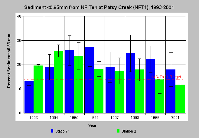
| Caption: Percent fine sediment less than 0.85 mm from wet sieve McNeil bulk gravel samples for 1993-2001 in the North Fork Ten Mile River at Patsy Cr (NFT1) are displayed above. Two stations (riffles) were sampled annually and bars represent the average of four McNeil cores at each and whiskers represent standard deviation and 95% confidence intervals. The reference value of 14% comes from the Ten Mile River TMDL and was only exceeded, including error bars in 1995 and 1996. Data provided by Hawthorne Timber Company. See Info Links for more information. | |
 |
To learn more about this topic click here .
To view the table with the chart's data, click Chart Table web page.
To download the table with the chart's data, click mcneil_nft1_85.db (size 4,096 bytes) .
To see meta information about the data table used for this topic click here
To view the table with the chart's source data, click Source Table web page.
To download the table with the chart's source data, click mcneil_source_ten.dbf (size 414,612 bytes)
| www.krisweb.com |