
| Area | North Fork Ten Mile |
| Topic | Sediment: Fines <6.4 mm from (NFT 5) NF Ten Mile at Camp Five 1993-99 |
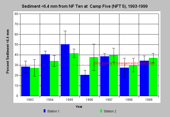
| Caption: Percent sediment less than 6.4 mm from McNeil samples from 1993-1999 in the North Fork Ten Mile River at Camp Five (NFT 5) is displayed above. Two stations (riffles) in a study reach were sampled annually. Bars represent the average of four McNeil samples at a station and whiskers represent standard deviation (95% confidence interval). Averages at both stations and the full range of samples in 1995 and 1997 were over the reference shown from Kondolf (2000) who reported that 30% sediment less than 6.4 mm corresponded to 50% decrease in survival of salmonids. The 6.4 mm results shown here were interpolated from 4 mm and 8 mm data provided by Hawthorne Timber Company. See Info Links for more information. | |
 |
To learn more about this topic click here .
To view the table with the chart's data, click Chart Table web page.
To download the table with the chart's data, click mcneil_nft5_64.db (size 4,096 bytes) .
To see meta information about the data table used for this topic click here
To view the table with the chart's source data, click Source Table web page.
To download the table with the chart's source data, click mcneil_source_ten.dbf (size 414,612 bytes)
| www.krisweb.com |