
| Area | South Fork Ten Mile |
| Topic | Sediment: Fine Sediment (<6.4 mm) Avg @ Mainstem SF Sites 1993-2001 |
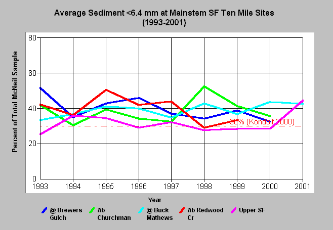
| Caption: Average percent fine sediment less than 6.4 mm from wet sieve McNeil bulk gravel samples in the Mainstem of the South Fork Ten Mile River are displayed above for the years 1993 to 2001. This chart is presented for consideration of trends over time and shows fine sediment (<6.4 mm) levels much higher than optimal for salmonid egg and alevin survival at all stations. The values used to create this chart are the average of all eight samples from two riffles each year. See individual sediment topics for standard deviations from individual riffles. The reference value of 30% is the mean value of 10 studies on sediment percentages <6.4 mm corresponding to 50% emergence of salmonids (Kondolf 2000). The 6.4 mm results shown here were interpolated from 4 mm and 8 mm data provided by Hawthorne Timber Company. See Info Links for more information. | |
 |
To learn more about this topic click here .
To view the table with the chart's data, click Chart Table web page.
To download the table with the chart's data, click mcneil_sf_time_64.db (size 4,096 bytes) .
To see meta information about the data table used for this topic click here
To view the table with the chart's source data, click Source Table web page.
To download the table with the chart's source data, click mcneil_source_ten.dbf (size 414,612 bytes)
| www.krisweb.com |