
| Area | South Fork Ten Mile |
| Topic | Sediment: Fines <6.4 mm (SFT 5) SF Ten Mile at Buck Mathews 1993-2000 |
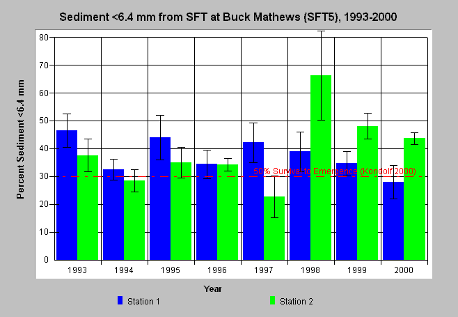
| Caption: Percent sediment less than 6.4 mm from McNeil samples in the South Fork Ten Mile River at Buck Mathews (SFT5) are displayed above for the period of record (1993 to 2001). Two stations (riffles) in a study reach were sampled annually. Bars represent the average of four McNeil samples at a station and whiskers represent standard deviation and 95% confidence intervals. Fine sediment (<6.4 mm) was over levels known to impair salmonid survival in several years, including the range of all samples from 1993, 1998 and 1999. The reference value of 30% is derived from Kondolf (2000) and is indicative of 50% salmonid egg and alevin mortality. Data provided by Hawthorne Timber Company. See Info Links for more information. | |
 |
To learn more about this topic click here .
To view the table with the chart's data, click Chart Table web page.
To download the table with the chart's data, click mcneil_sft5_64.db (size 4,096 bytes) .
To see meta information about the data table used for this topic click here
To view the table with the chart's source data, click Source Table web page.
To download the table with the chart's source data, click mcneil_source_ten.dbf (size 414,612 bytes)
| www.krisweb.com |