
| Area | South Fork Ten Mile |
| Topic | Sediment: Matthews Road Densities SF Ten Mile River Sub-Basins |
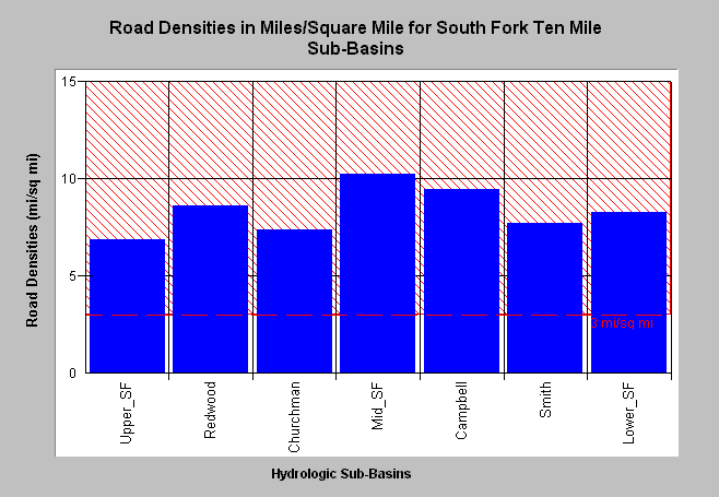
| Caption: Road densities as estimated by Matthews (2000) for South Fork Ten Mile River sub-basins are shown above in miles per square mile. Densities all exceed properly functioning condition according to the National Marine Fisheries Service (1996), which is less than 3 miles per square mile, the value shown for reference. The road densities range from 6.88 mi/sq mi in the Upper South Fork sub-basin to 10.23 mi/sq mi in the lower Mid South Fork Ten Mile sub-basin. Click on Picture to see a map of roads in the South Fork sub-basin. Click on Info Links for more background information. | |
 |
To learn more about this topic click here .
To view the table with the chart's data, click Chart Table web page.
To download the table with the chart's data, click roadsfmatt.dbf (size 1,894 bytes) .
To see meta information about the data table used for this topic click here
To view the table with the chart's source data, click Source Table web page.
To download the table with the chart's source data, click matthewstenroads.dbf (size 2,170 bytes)
| www.krisweb.com |