
| Area | South Fork Ten Mile |
| Topic | Sediment: V* from Churchman Creek, 1992 & 1993 |
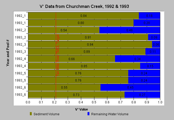
| Caption: This chart shows the abundance of fine sediment and the loss of pool volume due to excessive fine sediment in six Churchman Creek pools measured in 1992 and 1993. In 1992, Churchman Creek had a weighted average V* of 0.73. In 1993, this increased to 0.82. These values are almost 350% and 390% over the Ten Mile River TMDL V* target of 0.21. The V* in Churchman Creek is one of the highest measured in 61 Northcoast streams (Knopp 1993). The 1992 values are from Knopp (1993) and the 1993 values are from Lydgate (unpublished). V* is in decimal percent. A V* of 0.5 indicates that half of the pool is filled with fine sediment. Data supplied by NCRWQCB. See Info Links for more information. | |
 |
To learn more about this topic click here .
To view the table with the chart's data, click Chart Table web page.
To download the table with the chart's data, click vstar_churchman.dbf (size 1,598 bytes) .
To see meta information about the data table used for this topic click here
To view the table with the chart's source data, click Source Table web page.
To download the table with the chart's source data, click knopp.dbf (size 26,138 bytes)
| www.krisweb.com |