
| Area | South Fork Ten Mile |
| Topic | Temperature: FWA, South Fork Sites, 1999 |
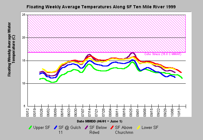
| Caption: The above chart plots floating weekly average temperatures in 1999 for six sites located on the South Fork Ten Mile River. The legend lists sites in sequence from upstream to downstream, showing that the stream warmed approximately 0.5 -1.5 degrees Celsius in the section between sites on the upper South Fork (SFT9) and above Gulch 11 (SFT12), and warmed another 0.5 - 1.5 in the section between SFT12 and SFT6 at Redwood Creek. The stream continued to warm from Redwood Creek down to SFT5 above Churchman Creek . The 16.8 degree C stress reference value for coho salmon was chosen based on Welsh et al. (2001). See Info Links for more information. Data provided by the Hawthorne Timber Company. Click on Picture for a map of locations and photo of monitoring site. | |
 |
To learn more about this topic click here .
To view the table with the chart's data, click Chart Table web page.
To download the table with the chart's data, click temp_sften_99_01_dailyavg.db (size 133,120 bytes) .
To see meta information about the data table used for this topic click here
To view the table with the chart's source data, click Source Table web page.
To download the table with the chart's source data, click tempraw_sftenmile_99_01.dbf (size 3,426,997 bytes)
| www.krisweb.com |