 |
Bibliography | Home | |
![]()
|
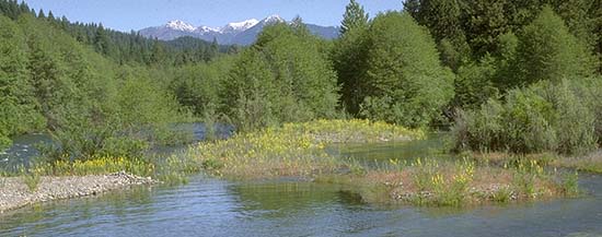
The Trinity River, the largest tributary of the Klamath River, begins in the Trinity Alps at elevations over 8000 feet. Major tributaries above Trinity Dam include Coffee Creek, Stuarts Fork, the East Fork Trinity and the upper main Trinity River. Below the dam the largest tributaries are Canyon Creek, the North Fork Trinity, New River and South Fork Trinity. The river runs south from its headwaters above Trinity Reservoir, turning west around Weaverville and finally running north to join the Klamath River at Weitchpec. Much of the Trinity River watershed is steep terrain and streams are often in deep, V-shaped gorges. The Trinity Basin is far enough in from the coast so that it experiences substantial climatic variation with snow fall in winter and very warm summer temperatures. Average annual precipitation ranges from 35-75 inches. Historically the Trinity River had large flood events during major winter storms or during spring snow melt. |
 |
|
Native Americans that inhabited the Trinity River basin for thousands of years relied heavily on the bountiful runs of chinook salmon, coho salmon and steelhead for sustenance. While Indians of the upper basin were displaced or extirpated, the Hoopa Tribe in the lower Trinity Basin was not defeated and remain intact in their traditional territory today. Early European settlers were drawn to the area in search of gold and the changes to the Trinity River as a result of mining activates were profound. Because the terrain of the Trinity River watershed is too steep for cultivation, the population of the area remained low after settlement. While Trinity County has traditionally been reliant on resource extraction, today tourism related to recreation is becoming a major contributor to the economy. In 1963, two large dams on the Trinity River were completed, blocking 109 miles of salmon and steelhead habitat. Just after the dam was completed, 90% of the historic flow of the river was diverted to the Central Valley for agricultural use. With the reduction in flow, the Trinity River channel narrowed and thick riparian vegetation began to encroach. Salmon and steelhead populations plummeted despite the establishment of Trinity River Hatchery right below Lewiston Dam. In the 1970's a Trinity River Task Force was convened to attempt to halt the decline of fisheries. In 1984, Congress passed the Trinity River Restoration Act (PL-98-541) that established the ten year Trinity River Restoration Program (TRRP). The TRRP has funded upland restoration, a large sediment control project on Grass Valley Creek, main stem restoration projects between Lewiston and the North Fork and, more recently, South Fork Trinity River restoration projects. The program has also lead to much more extensive fisheries monitoring and studies to determine sediment transport and the effectiveness of restoration activates. |
![]()
References
US Bureau of Land Management. 1995. Mainstem Trinity River Watershed Analysis. Redding, CA. 56 pp.
US Bureau of Land Management. 1995. Mainstem Trinity River Watershed Analysis. Volume II: Detailed Investigations. Redding, CA.
![]()
| www.krisweb.com |