
| Area | Regional |
| Topic | Sediment: Road Densities for All East Marin-Sonoma Planning Watersheds |
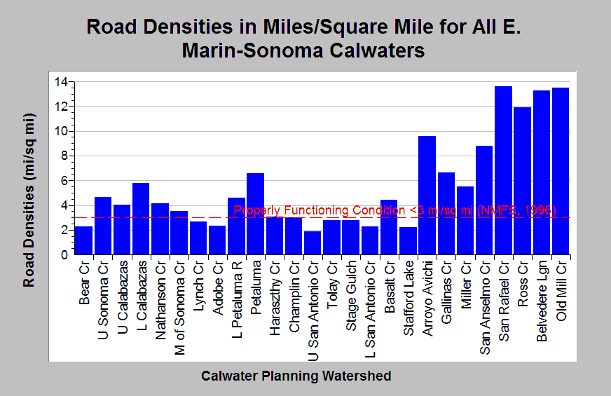
| Caption: The Chart above shows the density of roads in miles per square mile for all KRIS East Marin-Sonoma Calwater planning watersheds. The highest road densities tend to be in highly urbanized basins. Road densities are lower in Calwaters greater topographical relief. Most Calwaters have densities exceeding properly functioning condition according to the National Marine Fisheries Service (1996), which is less than 3 miles per square mile, a value shown for reference. Cedarholm, et. al. (1981) suggest that road densities should not exceed 1.6 mi/sq. mi. Road data originates from 1:100,000 scale topographic maps and under represent road densities, especially in urban areas. Roads densities are calculated by KRIS IFR staff in Arc Info. Calwater full names are located in the Chart Table. See Map for a map layer of basin wide roads. See Info Links for more information. | |
 |
To learn more about this topic click Info Links .
To view additional information (data source, aquisition date etc.) about this page, click Metadata .
To view the table with the chart's data, click Chart Table web page.
To download the table with the chart's data, click roads_densities_northbay_basinwide_100k.dbf (size 2,404 bytes)
To download the table with the chart's data as an Excel spreadsheet, click roads_densities_northbay_basinwide_100k.dbf.xls (size 6,144 bytes) .
| www.krisweb.com |