
| Area | Stemple Creek |
| Topic | Flow: Stemple Creek Estimated Average Monthly Flows, 1996 |
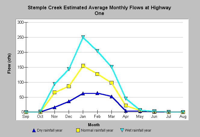
| Caption: Average monthly stream flows were estimated in Stemple Creek at Highway One by Questa Engineering Corporation for the City of Santa Rosa and U.S. Army Corps of Engineers, using a water balance analysis. Estimated average flows are presented for dry, normal, and wet rainfall years. A dry rainfall year is considered to be the lowest 30 percent of rainfall years, and a wet rainfall year the highest 30 percent of rainfall years. Note that estimates do not take into account diversion of water for agricultural use and therefore may be higher then actual values. See Picture for a map showing Stemple Creek at Highway One, as well as the location of the rainfall gaging stations used in the water balance analysis. | |
 |
To learn more about this topic click Info Links .
To view additional information (data source, aquisition date etc.) about this page, click Metadata .
To view the table with the chart's data, click Chart Table web page.
To download the table with the chart's data, click flowclimate_amerstemtolay_wtrbd_mnth_questa.db (size 10,240 bytes) .
| www.krisweb.com |