
|

|
| Background | Hypotheses | Bibliography | Maps | Home |
|
|
|
| Background | Hypotheses | Bibliography | Maps | Home |
Big River Basin Geology
KRIS Web Background Pages: Geology
![]()
Note: Geologic information, electronic maps and models within KRIS projects are meant to provide background information only and not as a decision making tool. California requires that licensed geologists be involved directly in decisions related to geologic conditions (see requirement). Endorsement of the contents of this page by the California Geologic Survey is not implied.
The Big River basin is comprised principally of Coastal Belt Franciscan Formation which is different from the Central Belt Franciscan formation in that it lacks greenstone, serpentine and chert (Kramer, 1974). The contact with the Central Belt Franciscan formation roughly follows the eastern boundary of the Big River basin. Marine terraces of various ages form the western portion of the basin. Caspar and Hare Creeks as well as other coastal tributaries to the north of Big River are also included in this project. They have fairly low-relief marine terraces with Coastal Belt Franciscan forming the hills to the east. Landslide models of shallow debris slides are also part of the KRIS Map project (see the KRIS Web background page on Modeling Shallow Landslides ).
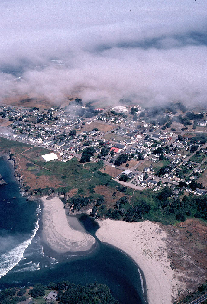 |
The Big River estuary is in the lower portion of the photo at left. The town of Mendocino sits on an uplifted marine terrace composed of material that was once under the seafloor. Geologists classify this as an emergent coast; because it is emerging from the ocean (Hardin, 1997). Click thumbnail to see the full sized image (177KB) |
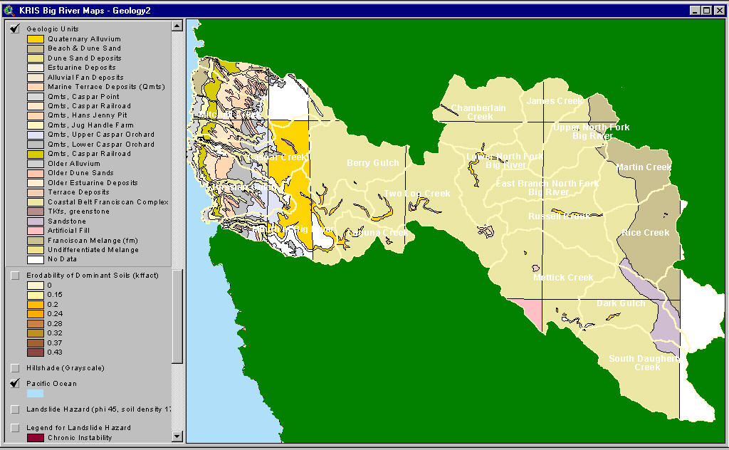 |
The map image at left shows the bedrock geology of the Big River basin provided by the California Division of Mines and Geology. The western portion of the watershed is mostly uplifted marine sediment and sand dunes. The dominant formation in the central part of the watershed is Coastal Belt Franciscan. To the east the Central Belt Franciscan Formation intrudes into the Upper North Fork Big River, Martin Creek, and Rice Creek planning watersheds. Outlines and names of Calwater planning watersheds are shown in white. (See CDMG metadata). (52 KB) |
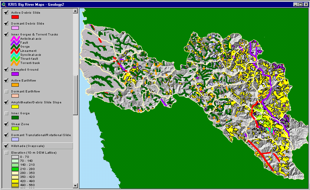 |
Thos image shows a map of geohazards for the Big River basin supplied by the California Division of Mines and Geology. Maps with active and dormant landslide features and earthquake faults can be used to assess erosion risk for watershed assessment or land use planning. (97 KB) |
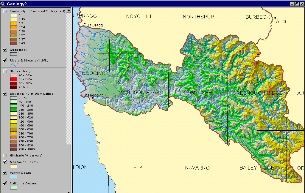 |
The image at left is a shaded relief map of the Big River basin showing elevation in meters. Also shown are towns, streams and a quad sheet index. From the KRIS Big River Map project, derived from 10 meter DEMs provided by CDF FRAP. (144 KB) |
The work of Kramer (1974) is useful in understanding the Big River basin, although it was specifically focused on the neighboring Noyo watershed. He concluded that three primary forces were responsible for the formation of the Noyo basin landform and bedrock geology: 1) large undersea landslides which piled material up against the contact point of the Farallone and American plates, which were colliding offshore of Ft. Bragg, 2) the plate collision itself and associated uplift, and 3) south trending compression on the American plate as the Triple Junction moved northward.
The bedrock of the Noyo Basin is largely sheared material and the Big River basin has the same characteristics. Kramer (1974) noted that in the Noyo watershed: "Because of the thick mantle of weathered rock, high rainfall, and steep slopes, surficial earthflows and mudflows are a very common occurrence in winter months. Nearly all road cuts and river channels exhibit evidence of rapid mass movement as a result of over-steepened slopes .The bedrock is highly fractured throughout the Coastal Belt and is subject to rockslides, slump and debris slides. Detailed studies in the Fort Bragg-Willits area, in relation to land development, have resulted in the conclusion that nearly all the rock is involved in either ancient or recent mass movement, and that any further road cuts or home site excavation will cause a given area to be subject to landsliding."
The 1906 earthquake seriously affected the town of Mendocino at the mouth of the Big River. The bridge across the river was damaged and a large chimney at the mill collapsed (see Big River History pages). The neighboring city of Ft Bragg was devastated by the quake. Oakshott (1972) provided an excellent account of the devastation of Ft Bragg and its rebound from the 1906 quake .
![]()
References
Bedrossian, T. L. 1986. Watershed Mapping in Northern California, an update. California Geology, February 1986.
Kramer, J.C. 1974. Geology and Tectonic Implications of the Coastal Belt Franciscan, Ft. Bragg-Willits Area, Northern Coast Ranges, California. U.C. Davis PhD. Dissertation, Davis, CA.
Matthews, G. 1999. Sediment Source Analysis and Preliminary Sediment Budget for the Noyo River. Graham Matthews and Associates, Weaverville, CA. (Contract 68-C7-0018. Work Assignment #0-18.) Prepared for Tetra Tech, Inc. Fairfax, VA.
Oakeshott, G.B. 1972. San Andreas Fault - Point Delgada to Ft. Ross. In: Geologic Guide to the Northern California Coast Ranges-Lake, Sonoma and Mendocino Counties, California: Annual Field Trip Guidebook of the Geological Society of Sacramento, 1972. p 83-93.
Short, Bill. California Division of Mines and Geology, Sacramento, CA. 916-322-4853
See a list of additional references at the California Division of Mines and Geology website: http://www.consrv.ca.gov/dmg
![]()
| www.krisweb.com |