 |
 |
| Background | Hypotheses | Bibliography | Maps | Home |
| |
|
| Background | Hypotheses | Bibliography | Maps | Home |
KRIS Web Backkground Pages: Habitat Types
![]()
The KRIS Big River CD contains habitat typing reports and data from stream surveys conducted by California Department of Fish and Georgia Pacific Company between 1993 and 1998. The Georgia Pacific survey data was provided by the current landowner, Hawthorne Timber Company. The CDFG survey data was provided by resources agency staff in Sacramento. Both surveys follow protocols described in CDFG (1998). Individual stream reports can be accessed in the KRIS Bibliography and the available raw data from Big River area surveys have been compiled into a Source Table. Several types of charts are displayed in KRIS Big River to summarize habitat conditions. These charts come from either summary data taken from reports, or a query of the raw database files.
CDFG habitat survey protocol involves classifying habitat units and describing 15 attributes for each unit, or a sample of each unit type. Summary data and charts in KRIS Big River show habitat frequency-by-length, maximum pool depth, pool tail embeddedness, and percent canopy cover. Special charts for exploring the distribution of datasets are also presented for residual pool depth, and shelter rating. These later attributes have uncertain value in assessing habitat conditions or as indicators of cumulative effects.
Habitat frequency can be used to roughly gauge problems of cumulative watershed effects on streams. When substantial erosion occurs in a watershed, pool habitats diminish by aggradation (filling in) (Madej, 1984). Subsequent habitat surveys will find the stream dominated by riffles or shallow glides and runs. These flatwater habitats may still be suitable for young of the year steelhead, but young coho salmon require pools, preferably with large wood.
Brown et al. (1994) suggested that pools of one meter in depth or greater were necessary for successful rearing of coho salmon juveniles; therefore, KRIS Big River has broken down pool depth to discern how many pools deeper than three feet exist in surveyed areas. Older age steelhead also rely on pool habitat. Chen (1992) based cumulative effects models for the Elk River, Oregon on whether three-foot-deep pools were being maintained. His hypothesis was that if pools were greater than three feet they would support yearling steelhead.
Summary Charts for Habitat Type Frequency
Summary charts in KRIS Big River display habitat data for all surveyed streams in the Big River area (basin-wide) or by sub-basin. This comparative chart style is more useful for analysis of conditions at the watershed or basin scale. Habitat typing summaries in KRIS combine the 22 total habitat types into four simpler categories: pools, riffles, flat water habitats and dry areas. These are consistent with CDFG level II habitat types. Habitat frequency by length is used instead of percent occurrence because the latter has less relevance to habitat availability and is less sensitive to cumulative effects. For example, streams that are aggraded (filled in) may still have numerous of pools of short length and a few very long runs and riffles.
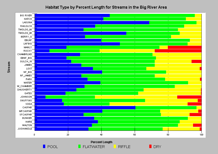 |
This chart shows the percent by length of the four basic habitat types, including DRY which would describe dewatered riffles, for each stream surveyed in the Big River area. Laguna, and Caspar Creeks are the only streams where pools comprise greater than 50% of the surveyed length, a benchmark for good quality coho habitat according to CDFG. Only eight of 33 streams have greater than 40% pool habitat, and nine streams have less than 25% pool habitat by length. Two Log Creek was surveyed by GP in 1996 and CDFG in 1998. (12 KB) |
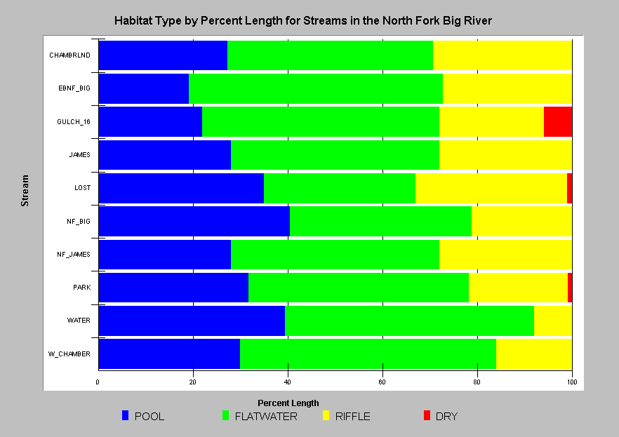 |
Pool habitat frequency in the North Fork Big River sub-basin ranged from 19% (East Branch) to 41% (North Fork Big). Percent pools by length is naturally higher in lower gradient channels, but is also affected by large wood and sediment. See the KRIS Web background pages about these topics for information on the factors which may be keeping pool frequency low in all surveyed streams of the North Fork Big River. (12 KB) |
Summary Charts for Maximum Pool Depth
Maximum pool depth is a discrete attribute with minimally subjective criteria for evaluation in the field. Deeper pools provide better quality habitat for coho salmon. Pools less than three feet deep may not provide suitable habitat for coho salmon, and California Department of Fish and Game biologists target maximum pool depth at greater than three feet for third order streams.
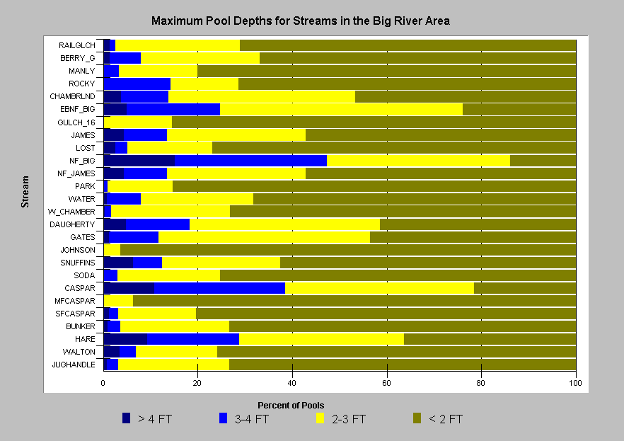 |
This chart shows that pools deeper than 3 feet are rare in streams of the Big River area. Other than in the relatively large channels (North Fork Big River, Caspar Creek, and Hare Creek), pools greater than 3 feet in depth comprised less than 25% of all pools. Lack of pool depth is likely limiting production of juvenile coho salmon in these streams if other conditions are suitable. |
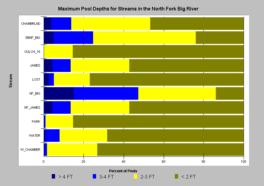 |
Maximum pool depths in North Fork sub-basin streams are similar in range to all streams surveyed in the Big River area. This metric is sensitive to stream order. The similarly sized Chamberlain, East Branch, and James Creek have 15-25% pools greater than 3 feet. In streams as large as the NF Big, maximum pool depths greater than 4 feet may be a better indicator habitat condition. The NF Big River has approximately 16% pools greater than 4 feet in depth. |
Summary Charts for Embeddedness
Pool tail embeddedness is a simple but subjective means of evaluating salmonid spawning habitat quality in the field. Pools tail crests are measured visually to determine to what degree potential spawning gravels might be embedded (partially buried). The California Department of Fish and Game (1998) categorize gravels less than 25% embedded as optimal for salmonid spawning. Other categories are 25-50%, 50-75% and greater than 75%.
 |
The chart at left shows that among all surveyed streams in the Big River area, high quality spawning habitat varied in occurrence from 0-80% of pool tails. Lower or mainstem tributaries had the highest levels of embeddedness. North Fork tributaries are apparently less embedded than South Fork tributaries, in general. The dramatic differences in data between surveys of Two Log Creek in 1996 by Georgia Pacific staff, and 1998 by CDFG staff may be an indication of the subjective nature of this attribute, or it may reflect changes in conditions over that short period. |
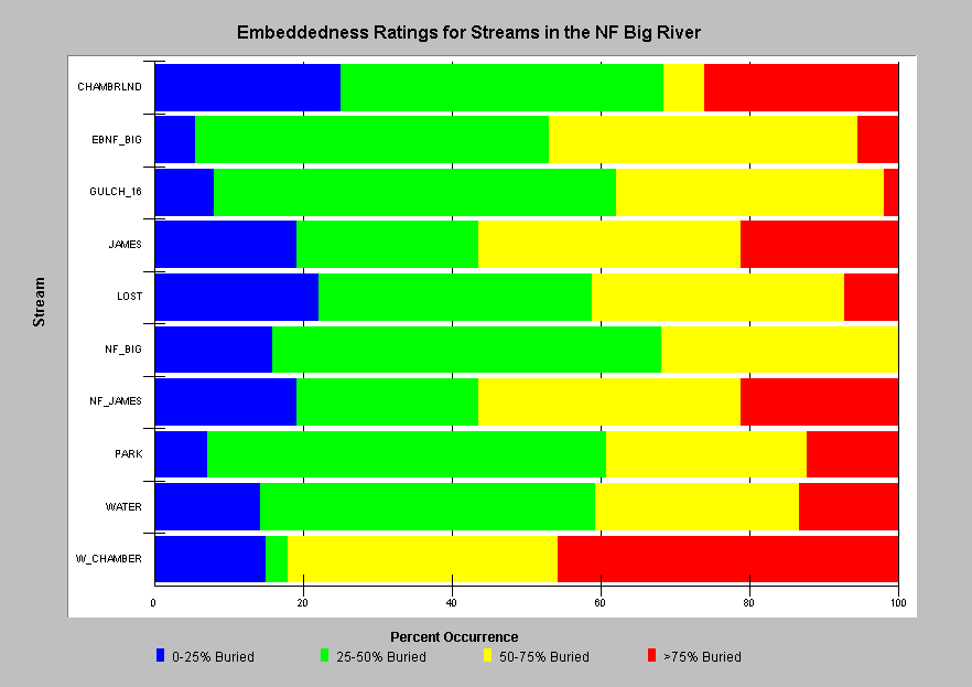 |
This chart shows embeddedness ratings for the North Fork Big River and tributaries. The data indicates that pool tail embeddedness was higher in West Chamberlain Creek than other streams in that sub-basin. |
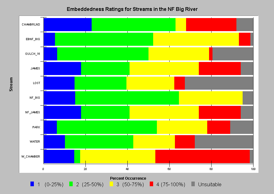 |
This chart shows all five classifications used by CDFG when evaluating pool tail embeddedness. Category 5 is used to classify pool tails that are unsuitable for spawning. It is not clear if pool tails receiving this category may also be highly embedded, or if they should be omitted from the sampling distribution for analysis, as has been done for this chart.. |
Summary Charts for Canopy Cover
Canopy is an indicator of whether the cool microclimate necessary for moderating water temperatures is present and also whether there is a large wood supply for recruitment into the stream (Poole and Berman, 2000). Even if there is a high shade component, deciduous canopy cover may be less able to provide a cool microclimate over the stream than a multi-tiered coniferous over-story.
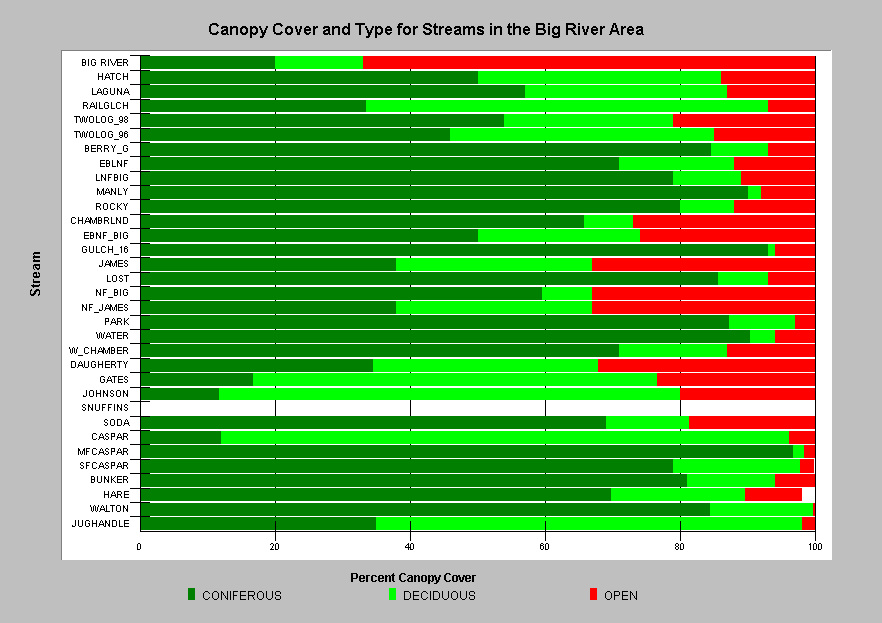 |
This chart shows the percentages of coniferous, deciduous, and open canopy from surveyed streams of the Big River basin. These measurements were not reported for Snuffins Creek. Streams are arrayed by sub-basin. Average coniferous canopy values are comparatively low for some South Fork Big River tributaries. Wider or larger streams will naturally have more open canopy as reflected by the 67% open canopy value for the mainstem Big River. |
 |
This chart shows that most of the smaller streams surveyed in the North Fork Big River have less than 20% open canopy. James Creek and NF James Creek, however, do have lower coniferous canopy and higher open canopy that might be expected for their size. |
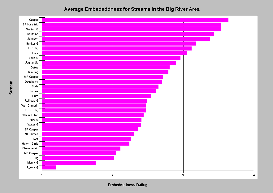
Average Values: Embeddedness, Maximum Pool Depth, Canopy Cover, and Shelter Rating
KRIS Big River contains raw data from habitat surveys of 32 streams in the Big River area. Data querying and specialized charting tools in KRIS have been used to present parameters from this data set which may be of use in watershed assessment. Each of the four charts below show average (mean) values per surveyed stream for one of the following attributes: embeddedness, maximum pool depth, percent canopy cover, and shelter rating. This chart style ranks streams by their value, and provides a quick examination of the range of values as well as those streams which rank high and low. Average values are commonly used in analysis, but it is important to remember that averages are minimally descriptive of the dataset, and are influenced by errors or outliers.
 |
 |
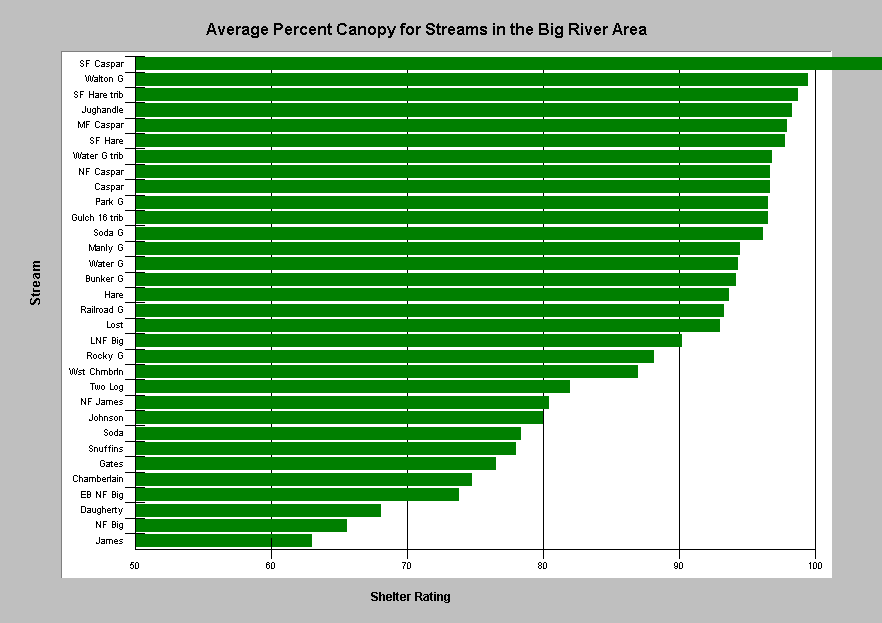 |
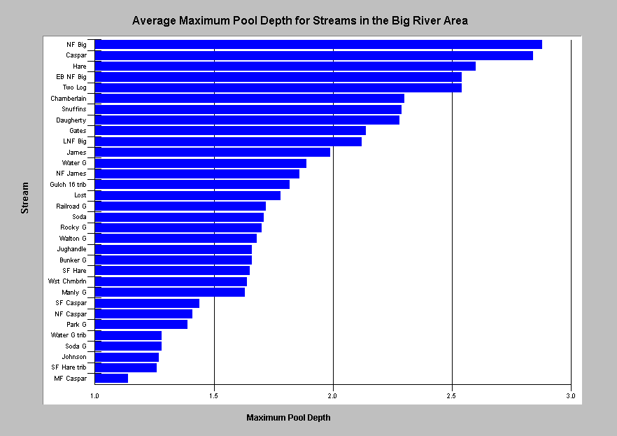
| Average pool tail embeddedness for streams in the Big River area ranged from 1.2 (Rocky Gulch) to 3.6 (Caspar Creek). | Average maximum pool depth for streams in the Big River area ranged from 1.14 feet (MF Caspar) to 2.88 feet (North Fork Big). | Average percent canopy cover for streams in the Big River area was as low as 63% (James Creek). The South Fork Caspar Creek value of 110% is the result of erroneous data entry. |
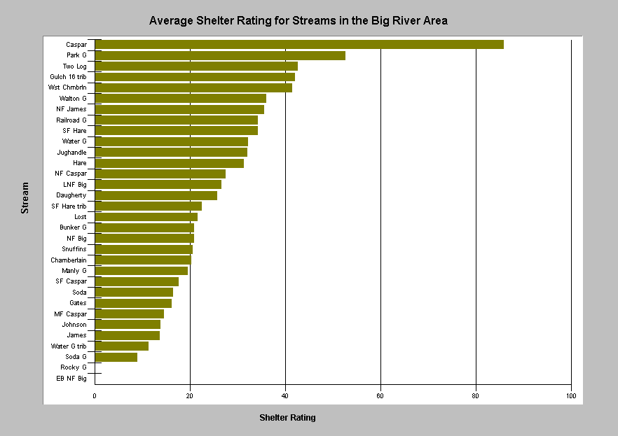 |
Average shelter rating in the Big River area ranged from 9 (Soda Gulch) to 89 (Caspar Creek), and was not measured in Rocky Gulch or the East Branch NF Big. The rating system multiplies the percent coverage of any salmonid fish shelter by a 1-3 score for the quality of the shelter present. According to CDFG, shelter ratings >120 indicate high quality salmonid habitat. |
Box-Plots for Exploring Data and Assessing Relative Conditions
The box-plot or box-whisker plot is a chart style suited for examining the distribution of data points, and provides much more information than an average, median, or any other single parameter. Box-plots describe the distribution of data for a single attribute, and can be used to compare that attribute across many streams. Box-plots in KRIS use the following seven parameters: the 5th percentile (Q5), the 10th percentile (Q10), the 25th percentile (Q25), the 50th percentile or median (Q50), the 75th percentile (Q75), the 90th percentile (Q90), and the 95th percentile (Q95). Box-plots can be easily prepared from raw data in KRIS by using the Build Table utility to first build the appropriate chart table.
Exploration of CDFG habitat data has revealed a small percentage of values for some attributes that are outliers, and in many cases, the result of mistakes during data entry. Percent canopy is one attribute that had approximately 3% of values in error due to incorrect decimal positioning. Maximum depth had a slightly lower error rate due to the same problem. Box-plots are only negligibly influenced by these errors, when they comprise less than 5% of the dataset. By contrast, averages can be strongly influenced by such errors.
Box-plots enable one to visually assess what streams provide a certain percentage of habitat in a condition greater or less than a specified value. Such visual assessment of data can be useful when exploring the relative condition of habitat in streams with regard to various targets. Examples are presented below.
Maximum Pool Depth, Residual Pool Volume, Shelter Rating, and Canopy
 |
The box-plot chart at left shows the distribution of maximum depth values measured for each moderate to large stream surveyed in the Big River area. Streams are arrayed by size: NF Caspar through West Chamberlain are 3rd order, Caspar through Chamberlain are fourth order. Only Caspar and Hare Creeks had more than 25% of pools measuring greater than 3.0 feet in depth. Median values ranged from 1.2 feet (NF Caspar) to 2.8 feet (Caspar). CDFG collected data during stream surveys in 1995-97. |
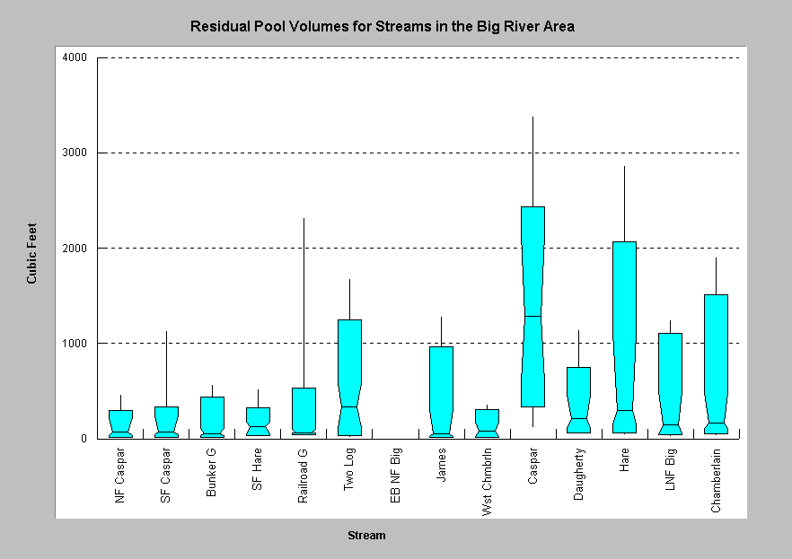 |
This box-plot chart shows the distribution of residual pool volumes for the same array of streams surveyed in the Big River area. The Little North Fork Big River and Daugherty Creek have watershed areas larger than Caspar Creek, but less than 10% of their pools were as voluminous as the median pool volume in Caspar Creek. The tall upper whisker on the plot for Railroad Gulch could be the result of errors or debris-jam formed pools that comprise more than 5% of the sample. . |
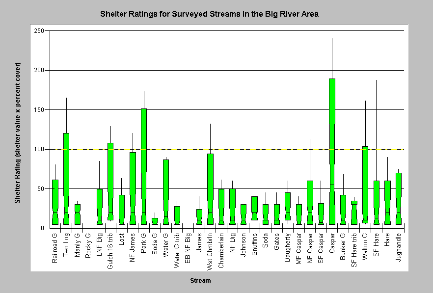 |
This box-plot chart shows the distribution of shelter ratings given to the units of all streams surveyed in the Big River area. The rating system multiplies the percent coverage of any salmonid fish shelter by a 1-3 score for the quality of the shelter present. Streams are arrayed by sub-basin. According to CDFG, shelter ratings >100 indicate desirable cover for salmonids. Caspar Creek is the only stream where more than 25% was rated above this value. |
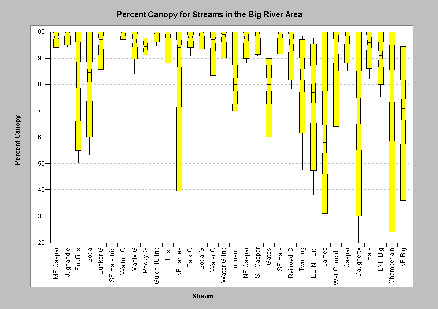 |
This box-whisker plot shows the distribution of percent canopy measurements for all streams surveyed in the Big River area. Streams are arrayed by size: MF Caspar through Johnson are 2nd order, NF Caspar through West Chamberlain are 3rd order, Caspar through Chamberlain are 4th order, and the NF Big is 5th order. While the occurrence of open canopy does correlate with stream size, trend outliers such as Snuffins, Soda, the East Branch NF, and James Creek indicate unusually open canopy. Caspar and Hare Creeks are shown with relatively high canopy cover conditions.. |
![]()
References
Brown, L.R., P.B. Moyle, and R.M. Yoshiyama. 1994. Historical Decline and Current Status of Coho Salmon in California. North American Journal of Fisheries Management. 14(2):237-261.
Byrne, M. 1997. California Salmonid Habitat Inventory: a Dynamic Segmentation Application. Earth Science Research Institute (ESRI), 1997 Annual Proceedings of ESRI Conference. CDFG, Inland Fisheries, Sacramento, CA.
CA Department of Fish and Game. 1998. California Salmonid Stream Habitat Restoration Manual. Third Edition. Inland Fisheries Division. California Department of Fish and Game. Sacramento, CA. 495 p.
Chen, G. 1992. Use of Basin Survey Data in Habitat Modeling and Cumulative Watershed Effects Analysis. Siskiyou NF. Published as part of USDA Forest Service Region 5 Fish Habitat Relationship Technical Bulletin Series, No. 8.
Georgia-Pacific Co. 1996. Habitat typing inventory reports: Ten Mile River Watershed. Surveys conducted during 1994/95. Unpublished file memo. Fort Bragg, CA. 103 pp.
Madej, M. 1984. Recent changes in channel-stored sediment Redwood Creek, California. Redwood National Park Technical Report #11, Arcata, CA. 54 p.
Mangelsdorf, A. and L. Clyde. 2000. Ten Mile Chapter (Chapter 4) excerpt from the Draft Assessment of aquatic conditions in the Mendocino Coast Hydrologic Unit. California Regional Water Resources Control Board. North Coast Region. Santa Rosa, CA. 77pp.
Poole, G.C., and C.H. Berman. 2000. Pathways of Human Influence on Water Temperature Dynamics in Stream Channels. U.S. Environmental Protection Agency, Region 10. Seattle, WA. 20 p.
![]()
| www.krisweb.com |