
| Area | Basinwide/Regional |
| Topic | Sediment: Matthews Landslides Debris Slides by Land-Use 1921-2000 |
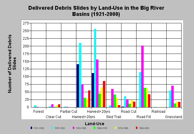
| Caption: The chart above shows the number of delivered debris slides in the Big River basin by land-use practice for the period 1921-2000. Estimates were generated from aerial photographs by Matthews and Associates (2001). Sediment delivery from debris slides largely occurred from areas that were harvested prior to 1966 and from road fill failures in this period. Additional slides occurred from skid trail failures and in grassland areas. Harvested areas and road fill are currently still significant debris slide sources. Matthews and Associates (2001) state: "Improvements in management practices since 1974 have resulted in decreases in road-related mass wasting and harvest-related surface erosion, although sediment delivery from these processes are still well above estimated background rates." See Info Links for more background information and links to references. | |
 |
To learn more about this topic click here .
To view the table with the chart's data, click Chart Table web page.
To download the table with the chart's data, click slides_debris_landuse_allsubs.dbf (size 938 bytes) .
To see meta information about the data table used for this topic click here
| www.krisweb.com |