
| Area | Basinwide/Regional |
| Topic | WQ: pH at Various Sites, 2001 (SWAMP) |
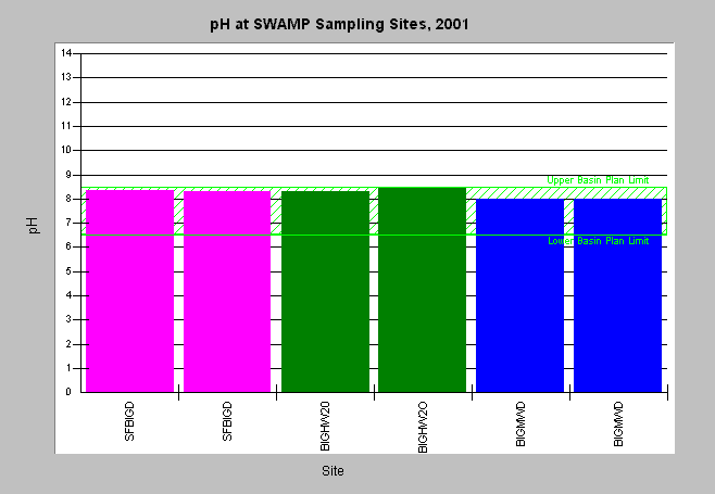
| Caption: The pH is a measure of acid/base conditions in water with neutral being a value of 7 with lower values representing acid conditions and higher values basic or alkaline conditions. All of the samples collected in the Big River watershed under the SWAMP program in 2001 fell within the limits set by the North Coast Regional Water Quality Control Board Basin Plan for the Big River and its tributaries. (PRESS F7 FOR EASIER VIEWING). The abbreviated site names shown on the x-axis are as follows: SFBIGD = South Fork Big River at Daugherty Creek BIGHW20 = North Fork Big River at Highway 20 BIGMWD = Big River at Mendocino Woodlands Note that a large number of other compounds were sampled, but are not plotted here. The complete data set is available in the Source Table. Click on the Info Links tab for more information. | |
 |
To learn more about this topic click here .
To view the table with the chart's data, click Chart Table web page.
To download the table with the chart's data, click wq_swampchart.dbf (size 3,430 bytes) .
To see meta information about the data table used for this topic click here
To view the table with the chart's source data, click Source Table web page.
To download the table with the chart's source data, click wq_swamp.dbf (size 39,688 bytes)
| www.krisweb.com |