
| Area | South Fork Big River |
| Topic | Sediment: Matthews Landslides Volumes per Land-Use Daugherty Cr |
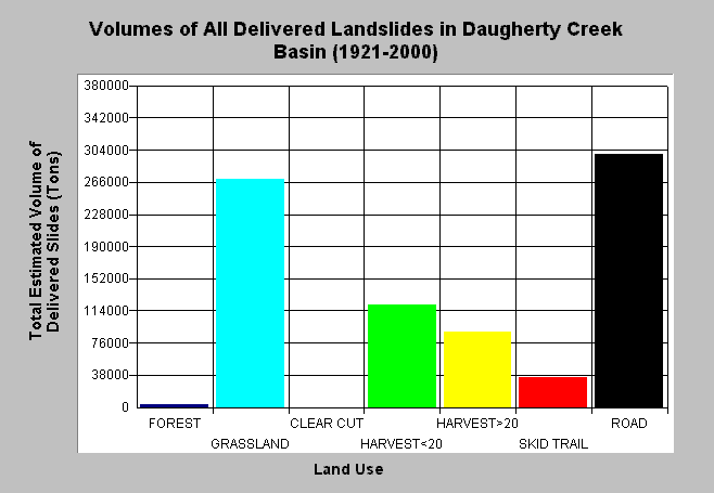
| Caption: The chart above shows Matthews and Associates (2001) total computed sediment delivery quantities in the Daugherty Creek basin per land-use. Road failures and slides in grassland areas contributed large sediment volumes in this basin. Harvested areas also important sediment sources. Matthews and Associates (2001) state: "Significant construction of new roads has led to increasing sediment yields from road surface erosion, despite improved practices. Under current conditions (1989-1999 period), management-related sediment delivery is estimated to be 51.7% of the total input." Estimates are generated from aerial photographs. See Info Links for more background information and links to references. | |
 |
To learn more about this topic click here .
To view the table with the chart's data, click Chart Table web page.
To download the table with the chart's data, click slides_voltons_landuse_dc.dbf (size 259 bytes) .
To see meta information about the data table used for this topic click here
To view the table with the chart's source data, click Source Table web page.
To download the table with the chart's source data, click slides_vol_tons_landuse_allsubs.dbf (size 2,464 bytes)
| www.krisweb.com |