
| Area | Basin-wide/General |
| Topic | Temperature: All Garcia Basin Sites, MWAT by Year 1994-2001 |
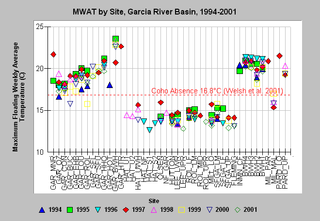
| Caption: The above chart shows maximum floating weekly average temperature (MWAT) for each site in the Garcia River Basin with available data in the years 1994-2001. Sites begin in the lowest Garcia River (GAR_MNR) and are listed in order along the mainstem Garcia River to the highest site (GAR_UPR). Sites following to the right are tributary locations, listed in the order they join the mainstem. Welsh et al. (2001) found that coho are not likely to persist where maximum floating weekly average temperature (MWAT) exceeds 16.8°C. See InfoLinks for more information. GAR = mainstem Garcia, HAT = Hathaway Creek, ROL = Rolling Brook, SFGA = South Fork Garcia, INMN = Inman, BW = Blue Waterhole Creek, MIL = Mill Creek, and PARD = Pardaloe Creek. Click on Map to see location of temperature monitoring stations. | |
 |
To learn more about this topic click Info Links .
To view additional information (data source, aquisition date etc.) about this page, click Metadata .
To view the table with the chart's data, click Chart Table web page.
To download the table with the chart's data, click temp_gar_mwat_chart.dbf (size 6,840 bytes) .
To view the table with the chart's source data, click Source Table web page.
To download the table with the chart's source data, click tempraw_gar_source.dbf (size 16,141,794 bytes)
| www.krisweb.com |